The GardenDespatches from The Satyrs’ Forest

Posts tagged as “County Durham”

Why is the Metro shaped like a pretzel?

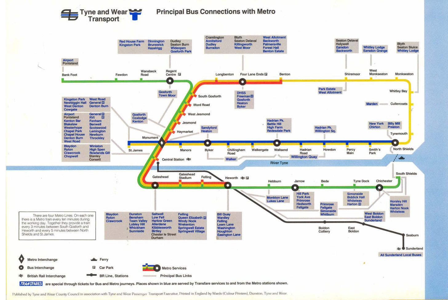
The Tyne and Wear Metro is a marvel of the British railway network: the only true metro system outside of London and Glasgow1, with fully accessible stations, beautiful typographic design, and only the occasional closure because someone stole all the copper wiring again. But amongst railway nerds, it is also known for one more puzzling detail: it’s a pretzel.

A map of the system, showing two lines — green and yellow — the latter of which goes around in a loop and intersects with itself
© Nexus

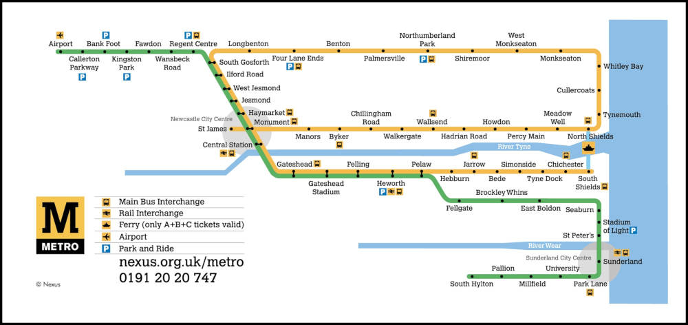
That’s right: you can, if you want, catch a Yellow Line train at Monument, go all the way around the coast, wind up right back where you started, and continue all the way down to South Shields just to rub it in. Put otherwise: there are four platforms and they’re all for the same line.

This is, as far as i know, unique to Newcastle. Bucharest almost gets there, but chickens out just before the line actually crosses over. Sofia nearly pulls it off but, in a shocking display of cowardice, redesignates its Line 4 as “Line 2” halfway through the loop, disqualifying them immediately. The Hague does something even more complicated, but it’s on a tramway and i can’t in good faith count it. And Vancouver used to have the same setup — even using the same colour — but switched to a perhaps more sensible timetabling in 2016 when an extension rendered it unworkable.

So… why? What’s the point? Let’s find out.

Part One: Why was it a pretzel?

As is often the case with urban rail, the constituent parts of the Tyne and Wear Metro were built at different times by different, competing companies, and were only later stitched together into a coherent network.

The first part of the loop to come online was the Newcastle and North Shields Railway, starting in 1839, who ran a service from the centre of town to (where else?) North Shields, later extended a teensy bit further to Tynemouth. The N&NSR’s mighty viaducts still carry our dinky yellow trains over the Ouseburn to this day.

Meanwhile, further north, coal mining in Northumberland was growing rapidly. (This brought great prosperity to the region, which would surely never ever end. Ever. Unless they closed the mines, but come on, why would that ever happen?) The existing main-lines found themselves choked by the influx of traffic, and in 1852, Parliament authorised the incorporation of the newfangled Blyth and Tyne Railway.

A map of the Blyth and Tyne network, showing it tracing the northern half of today’s Metro loop
Courtesy of the excellent Disused Stations website.

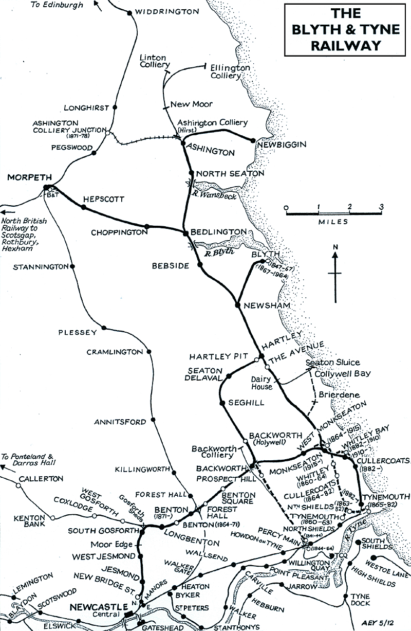
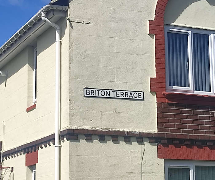
The B&T at first linked Bedlington and Blyth only to the staiths at Percy Main, but by the eighteen-sixties it had added branches to the centre of town — encouraging buildup in Newcastle’s northern suburbs — and to the growing seaside holiday destination of… Tynemouth.

Hm.

An old Ordnance Survey map showing the two lines at Tynemouth meeting, but not being able to transfer onto each other
Red is the Blyth and Tyne’s station; blue is the Newcastle and North Shields Railway’s.

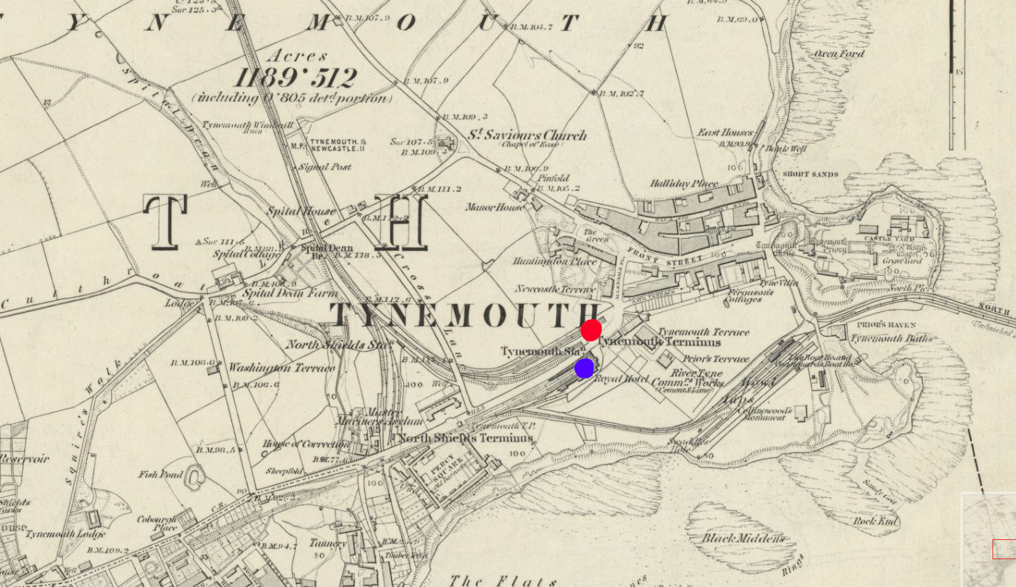
By the early eighteen-eighties, both the B&T and the N&NSR had been absorbed into the North Eastern Railway, which found itself in the awkward position of having two formerly competing stations right next to each other and no way for trains to transfer between the two. So, in 1882, the two competitors’ lines were linked up with a new alignment running closer to the coast, including the opening of a gorgeous palatial through station at Tynemouth, still in use by Metro trains and Sunday markets to this day.

A timetable showing the following stations in order: Newcastle Central, Manors, Byker, St Peters, St Anthonys, Walker, Carville, Point Pleasant, Willington Quay, Heaton, Walker Gate, Wallsend, Howdon-on-Tyne, Percy Main, North Shields, Tynemouth, Cullercoats, Whitley Bay, Monkseaton, Backworth, Benton, Gosforth, West Jesmond, Jesmond, Newcastle New Bridge St.
Hang on — “New Bridge St.”? A story for another time.

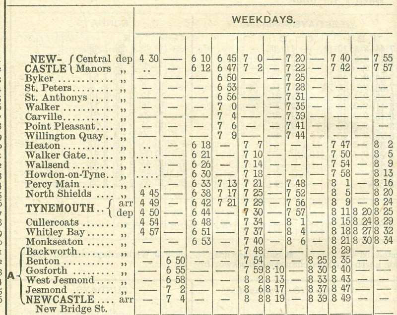
The earliest timetable i could find, from 1902, shows that trains were indeed running in a loop around the coast, from the city centre to Wallsend to Tynemouth and back, just as is possible today.

An old-timey electric tram on its way to Gosforth
Courtesy of the always-excellent Co-Curate

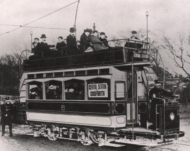
At the dawn of the twentieth century, however, the steam services were threatened by a rising competitor: the tram. No longer did you have to put up with noisy, steam-belching locomotives every day — you could get to exactly where you wanted to go, in style! This, of course, wouldn’t do, and so the NER embarked on a rapid programme of electrification. By 1904, the loop had fully switched over, and the network was rechristened the ✨️ Tyneside Electrics! ✨️

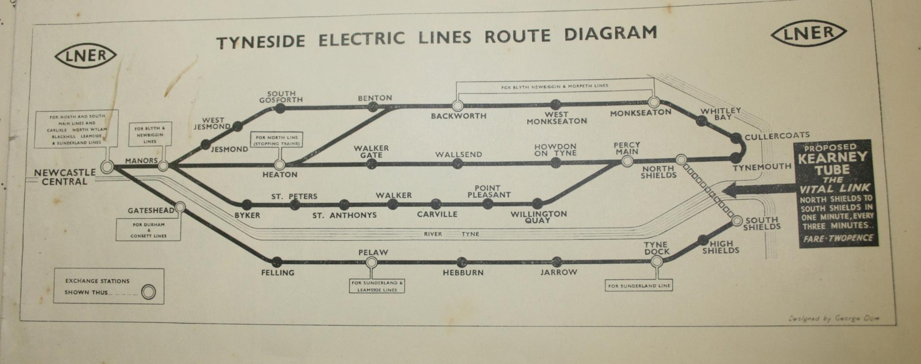
By this point, the network clearly resembled what we have today. Now, it didn’t quite loop over itself like today — everything went through Central Station; no perpendicular Monument tomfoolery here — and there was an extra branch snaking along the riverside which was never refurbished for the Metro era. But other than that, the geometry was pretty well set, and there would be no major service changes until the introduction of — what do you mean, you want to know what the big black arrow’s for?

Part 1½: The Kearney Tube

Whenever i show a diagram of the Metro to my non-Geordie friends, the first response is usually something to the effect of, “Why isn’t there a link between North and South Shields?” It’s a fair question, and the canned answer i usually give is that building one would be a lot of expense for little point, since there’s already a well-trafficked, well-loved ferry service between the two. Little did i know that it could well have been otherwise.

Elfric Wells Chalmers Kearney was an eccentric Australian engineer who spent much of his life trying and failing to convince city governments to adopt his all-new danglebahn, the Kearney High-speed Tube™. Here he is in 1910 with a model he made earlier:

An Edwardian gentleman in a dark coat stands next to a scale model of a railway descending down a steep gradient
Do you think they ever gave him his Blue Peter badge? (Photo courtesy of Recondite Harmony)

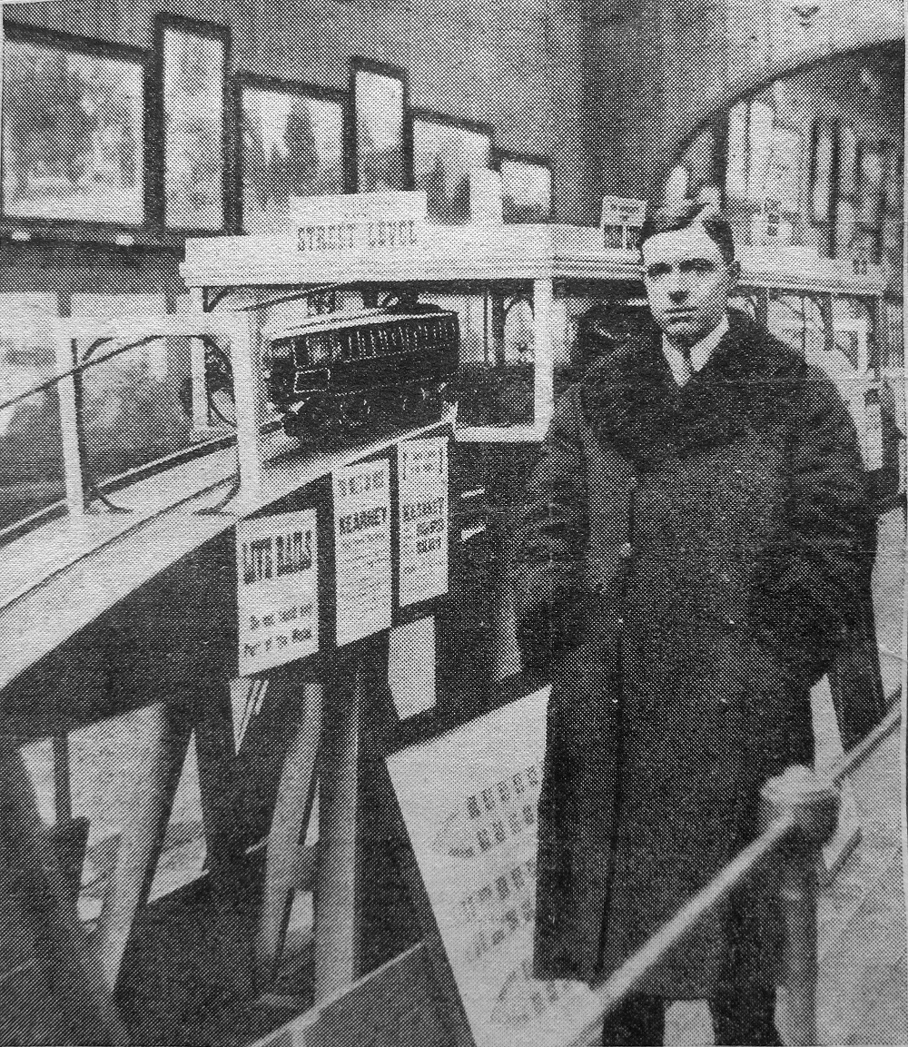
The “Kearney Tube”, as it was known, would be powered by the force of gravity, hurtling down a ⅐ gradient from stations just below the surface like a bizarro funicular before climbing gracefully back up, suspended between a monorail below and a guide rail above, which would (in theory) stabilise the train’s side-to-side motion so as to not induce vomiting in everyone who rode it.

Mr Kearney promoted his invention in cities as distant as Sydney, London, Portsmouth, and (if secondary sources are to be believed) Venice and New York, but it came closest to reality between North and South Shields.

Over sixteen thousand Tynemouthicans signed a petition calling for its construction, and in 1925 the government gave a provisional order approving its construction. Alas, when it came time for a parliamentary committee to give Mr Kearney’s dream the final go-ahead, they were rather more sceptical. He had raised nowhere near enough money to actually build the blasted thing, and the members were quite concerned about the impact it might have on the livelihood of the Tyne’s ferrymen.2

Mr Kearney held a grudge for the rest of his life. He made elaborate, typewritten conspiracy diagrams indicating who was paying off who, and gleefully wrote of the death of his opponents on the committee — or even those who were only tangentially connected:

Under pressure from Lord Ashfield, Henry Ford went back on his undertaking to finance the first Kearney Tube between North and South Shields. Not long afterwards Esdell Ford [sic], Henry Ford’s only son, was taken ill and died.

In 1939, he gave it one more go, partnering with the LNER — only for the outbreak of the second world war to put an abrupt halt to any civilian infrastructure plans. He would eventually write a science-fiction novel titled Erōne, where his his protagonist’s ideas are proven correct by a utopian society on Uranus, and if only the good people of Earth would listen!

Mr Kearney died in 1966, never having seen his utopia come to fruition. I was unable to find where or how, or even in which continent he is buried — he split his time between Australia and Britain, and he could plausibly have passed on either side of the equator. Still, i hope he’s up there somewhere, smiling down on all the shweebs, hyperloops, monorails, and other gadgetbahns of today.3

Part Two: Why is it a pretzel?

By the nineteen-sixties, the Tyneside Electrics had seen better days. Passenger numbers were falling, the trains of tomorrow were decrepit, and they weren’t even electric — British Rail had deemed it more cost-effective to run slower, dirtier diesel trains. The system had become a kittiwake4 around the North East’s neck. So, in 1971, the local transport executive commissioned a study — and they came back with a plan.

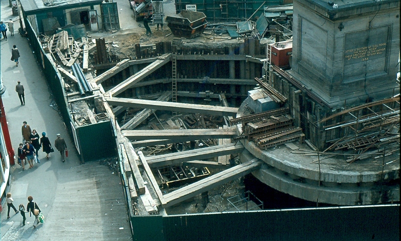
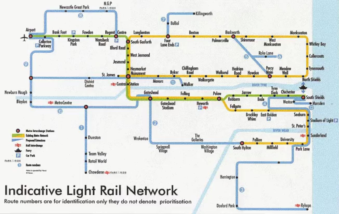
You know how the rest goes. Though the Tyne and Wear Metro would mostly reuse the existing routes mentioned before, they would all be linked up through a newly constructed central core underground — meeting in the middle at Grey’s Monument.

Construction of the station at Grey’s Monument, showing a deep underground trench dug around it
Courtesy of… the Metro’s official Facebook page? Sure, why not.
A map of the Metro as it was in the eighties, mostly the same as today but with a few “express” lines and without the branch south to Sunderland
A map of the system upon its completion in 1984, taken from this contemporary pamphlet, whose graphic design you simply must check out.

The pretzel shape was completed by proceeding one stop further from Monument to stubby St James’ Park.5 This was just a temporary terminus, of course — the station was built so that, in future, they could easily come back and extend it out to the long-underserved west end of the city. Quoth 1981’s “Tyne and Wear Metro: concept, organization, and operation”:

St James station is at the centre of an area designated for future office development and also serves the football ground; the station has also been designed to allow the system to be extended westwards at some future date.

So, eventually, that happened, right? They turned that little stumpy arm into a full-fledged extension. Right? …Right?

Part Three: Why is it still a pretzel?

In 1981, environment secretary Michael Heseltine vetoed any further extensions to the Metro system. Since then, the only substantive changes have been in 1991 — inking the airport to the rest of Newcastle — and 2002, when, after twenty years, the Tyne and Wear Metro finally reached Wearside. It is around 2002 that things get a little silly.

A map of various proposed extensions to the metro network
This map floats around the internet a lot, though i haven’t been able to tie it back to its original source.
A mockup of a tram running across a Newcastle street
Via the linked BBC article.

Shortly after service to Sunderland began, Nexus (the local transport operator) announced Project Orpheus, their grandiose plan to build a transport network fit for the twenty-first century. Bus rapid transit for everyone! A cable car in Gateshead! And, yes, the valiant return of trams to Newcastle-upon-Tyne, connecting the west end up with the city centre.

None of this happened. The plans were watered down and watered down until all that was left was the vague idea of refurbishing the Metro and making buses more frequent. The great recession and austerity presumably killed any hope it had left. You still get calls from local councillors to extend the system to their part of the area, but they seem unlikely to amount to much. So is all hope lost?

Well… remember the Blyth and Tyne Railway?

A Northern train crosses a viaduct over the Wansbeck river
A Class 158 crossing the Wansbeck Viaduct. CC-BY, courtesy of Steve Knight.

Passenger services along the B&T north of Backworth were given the chop by Dr Beeching in the nineteen-sixties. Combined with the end of coal, this was a one-two punch in the gut for working-class mining towns like Ashington and Blyth, leaving them some of the most impoverished in the country.

Local campaigners have been calling for its reopening since the nineties, initially to little avail barring a token mention in the ill-fated Project Orpheus plan. In 2013, Northumberland County Council started taking the idea seriously. In 2019, the transport secretary gave the thumbs up. In 2021, shovels hit the dirt. And in 2024, for the first time in half a century, trains carried passengers from Ashington to Newcastle.

It may be like pulling teeth, and it may cost more than we might like, but Britain can still build things — and local politicians seem to have noticed! In 2024, work began on the first serious proposal since Orpheus to extend the Metro; this time, to Washington, along the disused Leamside line.

A diagram of the proposed extension to Washington, showing the Green Line going in a loop
© Nexus

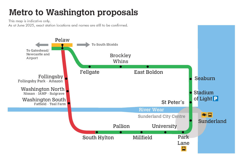
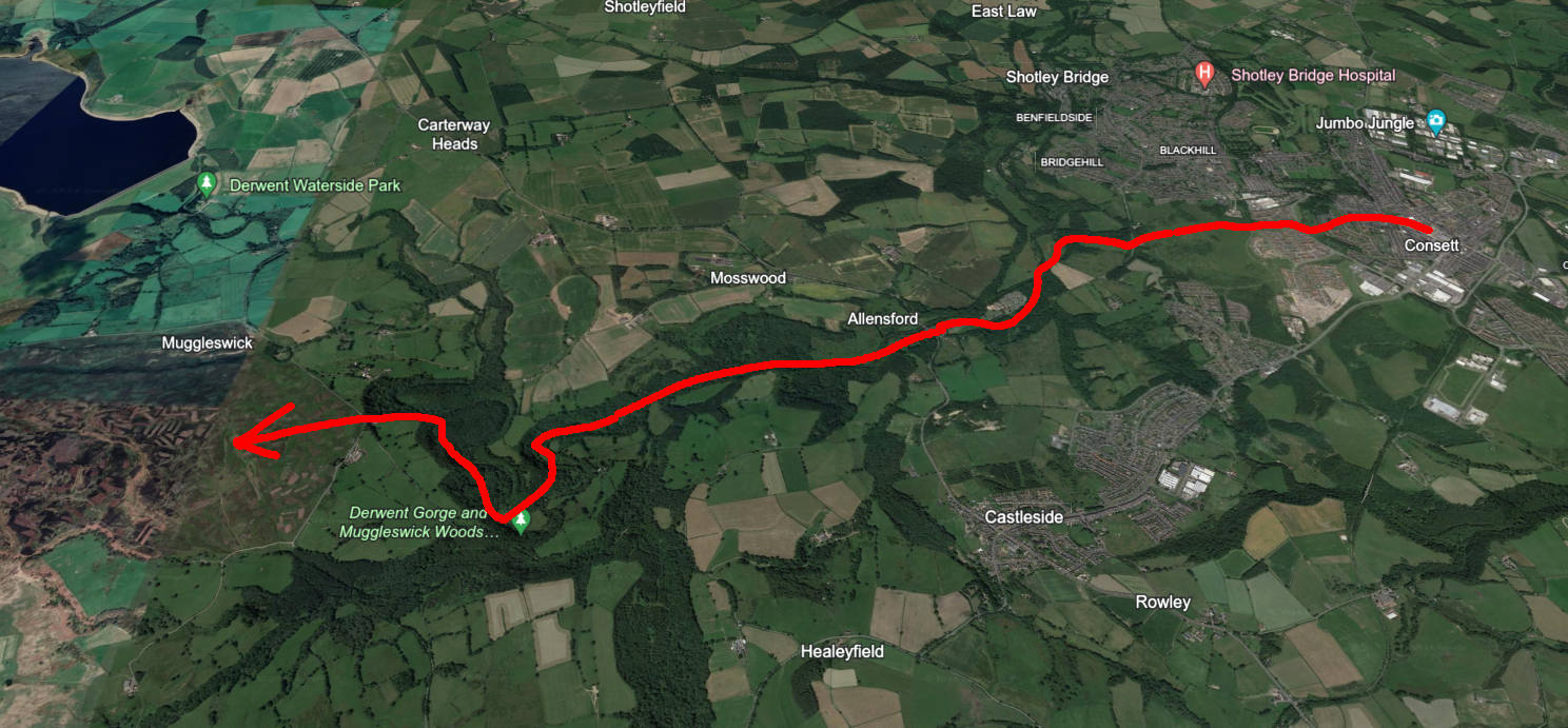
Curiously, the proposed extension goes in yet another loop. It’s hard to imagine this wouldn’t require some rejigging of how the network runs — a third line, perhaps? New platforms at Pelaw? But however they run it, it looks like, if it goes through — and that’s a big if — the Yellow Line may not be alone in its topological weirdness for long.

Unblogged July

I’ve done some fairly interesting things this month, and had planned to write posts for each of them — but, for whatever reason, none of them provided that particular spark to me. Maybe they just didn’t seem that interesting to explain to you, the reader, or maybe i didn’t know what to say about them except the obvious.

Nonetheless, it would be a shame for these events to pass into the annals of my journal without telling you about them. So! Here’s a brief summary of my unblogged July thus far.


Stephenson’s Rocket

I toddled off to Shildon to visit Locomotion, the local branch of the national railway museum. It’s the birthday of the railways, and thus boasts a disproportionate selection of anorak arcana — alas, you can’t go in the trains, but you get a pretty good look at the inside of Queen Alexandra’s royal train car, the erstwhile Birmingham maglev, and, most proudly, Stephenson’s Rocket.

Queen Alexandra’s royal train car The Birmingham maglev
An elaborately painted coat of arms
Locomotion also provides a lot to geek out about for any heraldry nerds.

A 1910s British street scene, recreated at Beamish A printed advert for a Large Pig

Beamish1 has been newly crowned Museum of the Year, so there was no better time to check it out. I hadn’t properly explored their new fifties town yet — the chippie and the old houses are wonderful, but the record store, crammed up the stairs, across an anachronistically modern mezzanine, and down a grey corridor, leaves much to be desired. Nitpicks about balcony design aside, it’s as great as ever, and, somehow, well worth the £33(!!!!!) asking price.


Finally, just yesterday, i went off to an Elbow concert hosted in a ruined mediæval priory by the sea. Belting out “One Day Like This” in the fading dusk light with five thousand other people standing on the same hallowed ground where monks tried to figure out where baby eels came from is a top-ten human experience.

A trip to Washington Wetland Centre

Washington1, a town in urban County Durham long since incorporated into Sunderland, is not a place where one expects much nature. The palatinate’s chirping woods and rolling Pennine moors are not so far away, and the path i took to get to today’s attraction led not through winding country roads but broad, grey industrial arteries, designed to ferry thousands to and from Nissan’s immense factory.

But at the end of the road, down by the river Wear, there lies a wee patch of idyll: the Washington Wetland Centre.

A reedy wetland, the Penshaw Monument clearly visible on a hill in the distance.
On a hilltop in the distance: the previously covered Penshaw Monument.

I’d come on a good day for it, clearly, as the first thing i saw coming out of reception was the staff corralling all the ducks together for their annual vaccination, by means of a ramshackle assemblage of mesh fences. (Crowd control for birds!) The littlest one kept trying to escape his jab like an ornithological Bobby Kennedy.

Most fabulous of all creatures of the air on offer are the eiders, the diva-est ducks in the world, emitting a chorus of sassy coos as they revel in their status as undisputed kings of the pond. (You’ll have to take my word for it, as i neglected to take a video, erring towards the side of it being better to live in the moment than through a phone camera. I was yet to realise what good blog-fodder the visit would make.)

A grey squirrel being all cute
As apologies for the lack of Eider Content, please accept this invasive rodent instead.

On the other side of the preserve a viewing area juts out to overlook the Wear — still salty and tidal this close to the sea — and an artificial saline lagoon, built to provide a home for those creatures who prefer a more brackish milieu. The signs tell me that, rare as they historically have been, more and more European otters have made their home along the wear, and the lucky visitor might hope to see one… if only the centre were open at dawn or at dusk, when they come out.

Two otters embracing on a little wall over a pond
Sign with a drawing of an otter saying “I may bite”
The sign’s not joking — Asian small-claweds’ bite force is enough to break your bones.

Not to worry, for the centre are also very proud of their main mammal enclosure: a family of utterly2 adorable Asian small-clawed otters. They’re a lot less squeaky than the ones at Northumberland Zoo, and wondering why, two theories popped into my head.

First, that it’s the Northumbrians’ fault. Their northern sibs were greater in number, a family of four to Durham’s two, and they were, by all accounts, masters of putting on a show. They appeared in an orderly fashion when their circadian rhythms told them it was feeding time, pipped and squeaked incessantly at the keeper until they got their fish, performed some cuteness, and then went back inside when their bellies were full. They knew exactly what they were doing, methinks.

Second, that the Washingtonian otters were grieving. I said there were two, the younger Buster and the elder Musa, and you might be hard-pressed to call that a family. But until this month, there were three. Mimi, the clan’s matriarch and a scamp who bonked so much they had to give her a lutrine IUD, passed of old age at fourteen (a good innings by her species’ standards, no doubt). When she went, they had to put her corpse back in the enclosure so the others would understand.

An otter looking out from the top of his castle

They were still otters. Still playful. But something about them seemed… morose. Maybe, in between the fish and the scampering and the puzzle feeders, they were still thinking about her.

On the way out, i passed a tiny observatory, cleverly named “Cygnus” for the constellation of the swan, used by night for the Sunderland Astronomical Society. I don’t know if it’s of much use this far into the zone of light pollution, but they certainly seem to enjoy it, so perhaps my relatively sky-privileged Northumbrian self shouldn’t play the lecturer. Perhaps that fateful night that Mimi died, a star in the sky began to twinkle a little brighter.

Postcards from kinda the area around Beamish, but not, like, Beamish itself, you kn

A tree which has fallen onto the autumn forest floor, taking not only the trunk but the roots with it, still covered in dirt
A reindeer stocking covered in dirt languishes inside a hole in the wall
I have to assume this has been here since at least last Christmas.
Peeking over the wall to reveal scaffolding for the façade of an old west town
I think this used to be(?) a centre for birds of prey. Not sure why it was done up like an old west town, if that’s the case…
I started hearing old-timey fairground music in the distance and it took me far, far too long to realise that it was coming from the old-timey fairground Beamish has. For fifteen minutes i was the most confused i had ever been in my whole life.

It can’t happen here

Feeling really quite glum over the news of far-right riots near here yesterday. I just keep coming back to the question… why Sunderland, of all places?

Not that it would be okay in any situation, but it’s not Leicester, where you have sectarian tensions flaring up. It’s not Southport, where you just had a mass stabbing. It’s not even somewhere with a properly substantial Muslim or immigrant population, like a Birmingham or a Boston. It’s Sunderland. Why here, in what is, pardon my bluntness, the White British1 working-class capital of the UK?

I don’t know. I guess i thought it couldn’t happen here. That we were nicer up north. Or that the scenery was too nice for people to get angry. Or that we were too left-wing even though Reform beat the Tories in every constituency. Or maybe that we were too deprived, and that we didn’t have anyone to scapegoat, because we knew it’d be shit no matter what.

Ach. History will trundle on as always, and in due time i’m sure the internet shit-stirrers and fundie imams will be joining hands and complaining about all those filthy undersea neo-post-Bahá’í immigrants from Atlantis taking our jobs. Maybe we can set up a football rivalry for everyone to redirect their hate into like they did in Glasgow. Who knows.

Ushaw Hall

An ostentatiously-decorated main chapel, with intricate carved wooden benches and walls, painted ceilings, and stained glass windows

Ushaw Hall’s website plays coy about itself. You can learn that guide dogs are welcome, they’ll be exhibiting interactive “Humanimal” sculptures next month, and that they're very proud of the pun “Ushaw in”, but curiously little about what the place actually is (or was). I went anyway.

To spoil the fun, it’s an old Roman Catholic seminary that was turned into a museum when people stopped being religious enough to care. The entrance makes that well clear; walking up from the car park, the curious visitor is flanked by an ostentatious neo-Gothic chapel on their left and modernist student housing on their right. (The latter remains unmuseumified, too boring to make much out of.)

A dimly-lit photo of church corridors with vaulted arches, the plain white walls lined with pictures on one side and dresses on the other. A brass statue of a saint sits in a niche off to the right, and the floor is decorated with a checkerboard of worn white and red tiles.

Right from reception there’s an interesting historical tidbit with a bust of Abraham Lincoln himself, who a helpful volunteer told me once attended Ushaw before he decided a more secular political career was right for him. (It was that or boxing, i suppose.) Upstairs is the Presidents’ Hall, whither the stairway looked off-limits enough not to chance it — so never mind that, and let’s instead turn right.1 This takes us down a series of winding hallways with wibbly tiled floor — as of now, an exhibition has lined them with wedding dresses old and new, including replicas of those worn by the royal family, creepy mannequin heads and all.2 More importantly and more permanently, these are the chapels of Ushaw Hall.

A smaller chapel, every inch decorated with tiny details
I neglected to take pictures in this part, so this one’s © Ushaw themselves.

They are beautiful, and have seen better days. The paint peels from a dimly-lit mural in a nook i presume is for choirists. In others, light dances in vibrant oranges and blues through expository stained glass. The brightest of them all, seen here to the right, invites its visitors to pray for Ukraine in a solemn reminder of the times.

These smaller shrines have an intimacy to them that reflects the house’s hush-hush history. First exiled from England, the Catholics settled in the small town of Douai, in the north of France — only to be forced out again by the secular fervour of the French Revolution. Even then, they struggled to find welcome in a staunchly Protestant Georgian England, until a sympathetic aristocrat sold them land in Durham’s secluded hills. The hall itself was built with the façade of an unseeming terrace, only showing its religious nature to those within.

An elaborate tabernacle

Onwards, then, into the star of the show — the main chapel. Pews upon pews span the long gap between the entrance and the colossal tabernacle, behind which the walls are adorned with what first looks like simple ornament but reveals itself to be tightly-packed black-lettered Latin. You can tell it’s Catholic by the eagle in the middle, the Vatican having never quite given up its attachment to its Roman roots.


…Upstairs is the Presidents’ Hall, whither the stairway looked off-limits enough not to chance it — so never mind that, and let’s instead turn left. Winding at right angles around the central court we first arrive at the library, or what little you can access of it. Management and the university are promising big things… eventually… once they restore everything… and catalogue it… and… oh, sod this, let’s go to the café.

[One hot chocolate later…]

A wee bookshop with dark wooden shelves and religious posters
This is a wholly unrelated bookstore found elsewhere on church grounds. Behind the camera is a fireplace. Yes, i am kicking myself for not photographing that instead.

As we were. Further along we find find the mess hall, where aspiring clergy once ate in silence, with only the wet sopping of a hundred English breakfasts reverberating back and forth across the walls. These days it’s used for noisier conferences and school trips, fitted with identikit metal and plastic tables and seats which don’t do much to complement the nineteenth-century décor.

Some time later, past the temporary exhibition of inkjet printouts of old maps3, our trip comes full circle. As i walk home through the well-kempt garden and around the reedy old pond, i might not have been convinced by the seminary’s faith, but i have been convinced of their taste in interior decoration.

Information for visitors

  • Admission: £10 per adult, £6 per child, free for under-fives
  • Address: Ushaw Historic House, Chapels & Gardens; Ushaw Moor; Durham DH7 9RH
  • Accessibility: An accessible entrance is available, and the gardens have paths suitable for wheelchairs.
  • Arriving there: Accessible by car along the A167, and the 52 bus also intermittently stops.

A despatch from Consett

Hello. I’ve been to Consett. I thought you might like to hear about it. (Gosh, i’ve missed writing that.)

It’s been a miserable year so far weather-wise, so wind-swept, cold-nipped, and rain-soaked that it took until April for me to look outside and go, ah, not a bad day, let’s go for a jaunt.

A map showing the planned route

The plan was simple: get a bus into Consett and head straight for the nearest hill. A short and sweet saunter through woods and farmland; short compared to some of my previous odysseys from Newcastle to the Wansbeck, sweet compared to the scenery in the more populous parts of the palatinate. (It was not to be.)

A storefront for "Teatan Lounge and Lunch" and "Oasis Tanning Salon"
I’m at the bubble tea / I’m at the tanning salon / I’m at the combination bubble tea and tanning salon

We start in the centre of town, a humble lower-middle-class affair whose high street would strike southerners as horrifyingly dilapidated and northerners as above average — nice enough, at least, for the area’s local MP to choose it as his base of operations. Around the corner from the cinema1, the pedestrianised and sensibly named Middle Street plays host to (in decreasing order of classiness) a provider of musical instruments, an independent sweet shop–gift shop–pet shop, a building society, a Greggs, a Superdrug, an animal rescue shelter, a frozen food emporium, a Turkish barber, Ladbrokes, a vape shop, another vape shop which also sells computer parts and repairs your phone (my lawyers say i can’t call it a mob front), and Barry’s Bargain Superstore.

A streetscape A nice old church with a red sign out front

This dumps us onto a crossing onto Parliament Street, where the Ga­li­le­an­ically inclined can attend the charming parish church (with “messy church” every month for the tots). I follow it down its procession of historic terraces, in a rather literal sense: Briton Terrace, Saxon Terrace, Norman Terrace, and then to spite me they finish it off with the pattern-breaking Tudor Terrace. I suppose it could have been a later addition, going with Stuart Court across the road, as well as Georgia and Edwardia Courts, two small cul-de-sacs i only noticed on Google Earth after the fact… but that sequence gets thrown off yet again by the road whence those two branch off, Romany Drive, which unless they meant to write “Roman” but hired a dyslexic cartographer has sod all to do with the other streets.

A street sign proclaiming this lane to be known as Briton Terrace

A path bearing at its mouth a welcoming sign (all caps, “no part of this land is dedicated to the public, any use of this land is entirely at the user’s own risk, et cetera, et cetera”) marks a liberating end to our onomastic confusion, funneling us down a sloping green crescent of parkland into a reclaimed steelworks. (It’s always a reclaimed steelworks.)

A quintessential English landscape stretching across one’s entire field of view
A steep path downhill
Cue the music.

Finally, we reach the end of the funnel, where the light pours from the sky, the buildings abruptly stop, and any wayward ramblers are left with only a gorgeous view of Durham’s rolling hills stretching out before them. This exact moment, this exact view — this is why i get out. To sit on the edge of a hill, the dull traces of modernity firmly behind you, and see the country not devoid of man’s presence, but shaped by it, over hundreds and thousands of years, from hunting-grounds to cleared forest to farmland to steelworks to grass for grass’s sake, a place where, like the terraces of Parliament Street, you can hear England’s history sing in your veins.

Anyway then there’s a really steep path downhill where i almost slipped and fell like Super Mario going down a slide.

A graffiti-covered pipe crossing a ditch inside a steel frame

Traipsing down steps i’m not 100% sure were public and over a road made of more pothole than asphalt i wind up following a burn to the River Derwent. This is where our route’s industrial past makes itself seen. Every few yards a worn sign pops up warning of a “drainage ditch”, or a graffiti-blanketed pipe crosses the rain-cleaved dene; at the very end, a picnic table by a former pump house grants me some respite.

I take stock of myself. My phone’s battery, always surprising me with innovative ways to run out, is in danger of crossing the ten-percent mark. It’s the first nice day of the year, but that also means i’m out of shape and out of practice: i won’t be able to make it all the way.

Equally, i’d be a fool to clamber back up all that. I keep walking. The rushing burn has become a tranquil river, its waters still enough to see your reflection. I think to myself that if you’re going to name a pencil company after a river, this one’s not a bad choice.2

Civilisation creeps back in with the tell-tale sounds of power tools. This is Al­lens­ford Holiday Park, a modest gathering of caravans proudly advertising itself as “near the outstanding Northumberland National Park”. (It isn’t.) When i get there it’s thronged by teen schoolboys freshly out, chattering about video games and lining up for ice cream. (Something, something, nature is healing.) Checking Google Maps with what power i have left reveals my worst fear: there’s nowhere to go but up.

The distance is short, but the slope is grueling. I convince my legs to heave themselves up along the side of pave­ment­less roads, ducking into fallow fields and passing places wherever i can find them. It gets worse the further i get. By the first field, i’m a little out of it. By the Catholic boarding school, i’m utterly exhausted. When i climb what i think is the final hill, only for perspective to cruelly show yet more around the corner, i wonder if this is what hell is like. But i make it — sweating and breathless, hydrating myself sip by sip, i make it to the bus stop, and wait. The driver, when he comes, must think i’m a zombie, but i’m glad to be on my way home. Note to self: don’t take that big a break again.

A dispatch from Barnard Castle

A shot looking up at an old Georgian palace with glass trees in the foreground

Hello. I’ve been to the Bowes Museum. I thought i might tell you about it.

Housed in a gloriously incongruous French mansion in the small town of Barnard Castle1, it was built to house the art collections of the noble Bowes-Lyons — a family lucky enough to count the Queen Mother herself among their members.

Its collection lies largely parallel to the “main” visual arts: ceramics, fashion, textiles, furniture, and other such things which must account for function as much as form. Most of it plunges headfirst into the latter, a bit frilly even for my often anti-modernist tastes, but i did like this caduceus-adorned wooden cabinet:

A dark wooden cabinet whose middle is adorned with a beautiful embossed caduceus

The star of the show here is the Silver Swan, a gorgeous eighteenth-century automaton which preens and sways on a bed of glass water. Unfortunately, it’s broken, and the closest you’ll get to see it is its dismembered corpse awaiting restoration, so [raspberry noise]. You can, however, see their exhibition on its legacy, which houses a wonderful collection of modern animatronics made by crafters and tinkerers from all over the world, like this 10/10 pianist:

There are a few items which don’t fit into the above. They’ve managed to snag some real Goyas, Canalettos, and El Grecos. (Los Grecos?) They even have Charles Babbage’s Difference Engine, somehow — i assume it’s on loan from London?

Information for visitors

  • Admission: £15.50 for an annual membership; £13.50 for locals — don’t be fooled by the eye-watering £18 day ticket for shmucks!
  • Address: The Bowes Museum, Newgate, Barnard Castle, DL12 8NP
  • Accessibility: The museum has an accessible entrance and a lift serving all three floors.
  • Getting there: Bus network’s fucked at the minute. Sorry.

The Penshaw monument

On a hilltop in County Durham sits the Penshawi monument, a nineteenth-century folly built to commemorate the late Earl of Durham. It’s always been on my bucket list, but it’s a bit of a pain to get to via public transport, and i’d never found the time — last week, though, i found myself with some time off and decided to make the trip. I’ll let the pictures do the talking from here…

A panoramic view of a sprawling country park, with some noticeable barriers put up for a race. In the distance, upon a hill, lies a building rather resembling an old Greek temple.
A view of the monument from the nearby country park. As you can see, there was a motorbike race on at the time, which somewhat dampened the otherwise-peaceful atmosphere. Tut tut.
On the top, the same building from before, now pictured from a rather closer distance, on a punishing set of stairs. Its façade is black with soot. On the bottom, a pristine ancient Greek temple, surrounded by a row of hedges.
The monument was based on Athens' temple to Hephæstos, though in a rather scaled-down format (see the lack of any kind of roof).
The sun shines through the monument's columns.
We weren’t allowed inside the naos, as they were busy setting it up for that night’s Lumiere festival.ii (They did let some of the people walking their bulldogs up — perhaps because they were too scared?)
The country park also has this neat little henge, with viewfinders pointing towards some well-known County Durham sites — that little black square you can make out is Durham Cathedral.

Information for visitors

  • Address:
    Chester Rd, Penshaw, Houghton le Spring DH4 7NJ
    .
  • Accessibility: Getting up to the monument requires a steep hike up a hill; if you have impaired mobility, you may want to think twice before going.
  • Getting there: The hill is served by the A183 road and the 2, 2A, and 78 buses. The nearest train station is Chester-le-Street, five miles away.
  • The National Trust sometimes offers tours of the top of the monument, though those are currently suspended.

High Force

Verborgen tussen de heidevelden en Penninsche pieken van County Durham ligt de machtigste waterval in Engeland. Het water van High Force tuimelt over 22 meter en 300 miljoen jaar rots naar het poel beneden. De waterval is ontstaan waar de rivier de Tees de Whin Sill kruist, een harde plaat van stollingsgesteente die een groot deel van het noorden van Engeland bedekt.

Als het waterpeil hoog genoeg is splitst de kracht zich in twee stromen, waarvan er een de andere kant op gaat rond de rotsen — na stormen kan het zelfs het hele plateau overstromen. Helaas, mijn groep had niet zoveel geluk, ondanks recente regenbuien.

De familie Raby, de eigenaars van het landgoed, vragen £5 om het uitzicht vanaf de voet van de waterval te mogen bewonderen. De waterval torent boven degene die durft naar beneden te gaan… en die niet zal missen dat er enkele mensen staan boven aan de rotsen. Die hebben helemaal niets betaald, want zij wandelde langs de gratis Penninische Weg. Verdorie.

Informatie voor bezoekers

  • Adres:
    High Force, Forest-in-Teesdale, Barnard Castle, County Durham, DL12 0XH, Verenigd Koninkrijk.
  • Bereikbaarheid: Openbaar vervoer is schaars in dit deel van het land, dus u kunt het beste een schilderachtige autorit maken door de Pennines en het negentiende-eeuwse dorp Middleton-in-Teesdale.
  • Prijs: Het Raby landgoed rekent £5 voor toegang via de bodem, maar de top is gratis toegankelijk door een wandeling langs de Penninische Weg.
  • Toe­gan­ke­lijk­heid en faciliteiten: Het pad is, voor zover ik weet, niet rol­stoel­toe­gan­ke­lijk. De familie Raby houden toiletten en een hotel voor wie wil overnachten.

High Force

Nestled amongst County Durham’s moors and Pennine peaks lies England’s mightiest waterfall. The waters of High Force tumble over 22 metres and 300 million years of stone, down into the plunge pool below. The falls were formed where the river Tees meets the Great Whin Sill, a tough slab of igneous rock covering much of the north of England.

When the water level is high enough, the force splits into two streams, one going the other way around the rocks — after storms, it can even overflow the plateau entirely. Alas, despite recent showers, my group were not so lucky.

The Raby family, owners of the estate, charge £2 to see the view from the base of the falls. The falls tower over any mere human who dares navigate down, demanding one’s respect and attention… and making it unmissable that, at the top of the falls, there are several people who walked their on their own via the Pennine Way, not having to pay a single dime. Drat.

Information for visitors

  • Address:
    High Force, Forest-in-Teesdale, Barnard Castle, County Durham, DL12 0XH.
  • Getting there: Public transit connections are few and far between this far into the countryside, so your best bet is to take a scenic drive via car through the Pennines and the nineteenth-century village of Middleton-in-Teesdale.
  • Price: The Raby estate charges £2 to access via the bottom, but the top can be freely accessed by a hike along the Pennine Way.
  • Opening times: 10:00–16:00.
  • Accessibility and facilities: The trail is not, to my knowledge, wheelchair-accessible. The site contains toilets and a hotel for anyone wanting to stay the night.