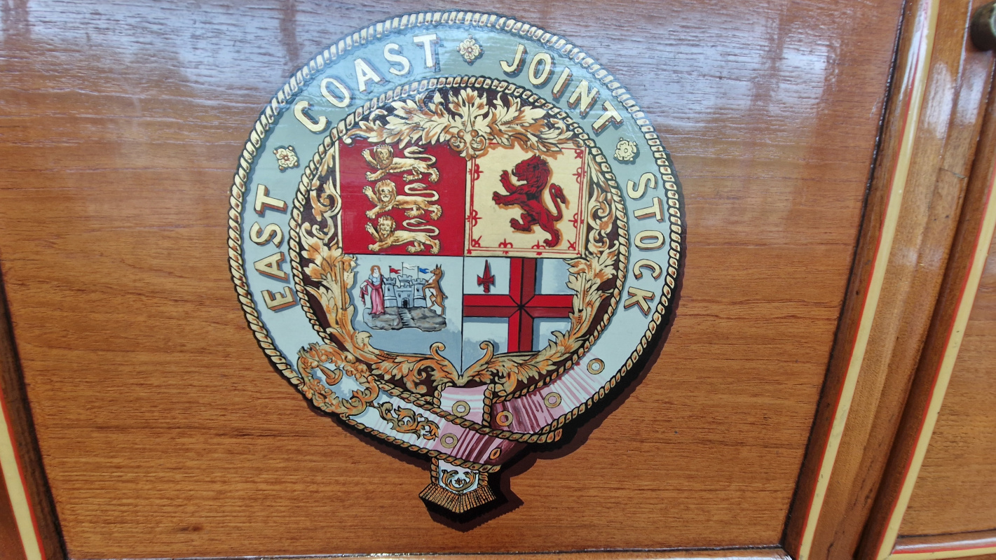
The Tyne and Wear Metro is a marvel of the British railway network: the only true metro system outside of London and Glasgow1, with fully accessible stations, beautiful typographic design, and only the occasional closure because someone stole all the copper wiring again. But amongst railway nerds, it is also known for one more puzzling detail: it’s a pretzel.
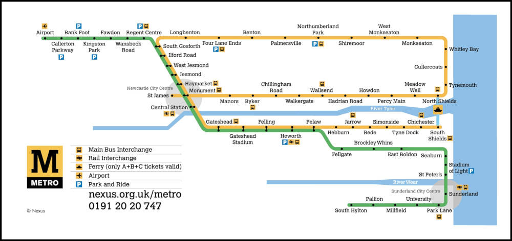
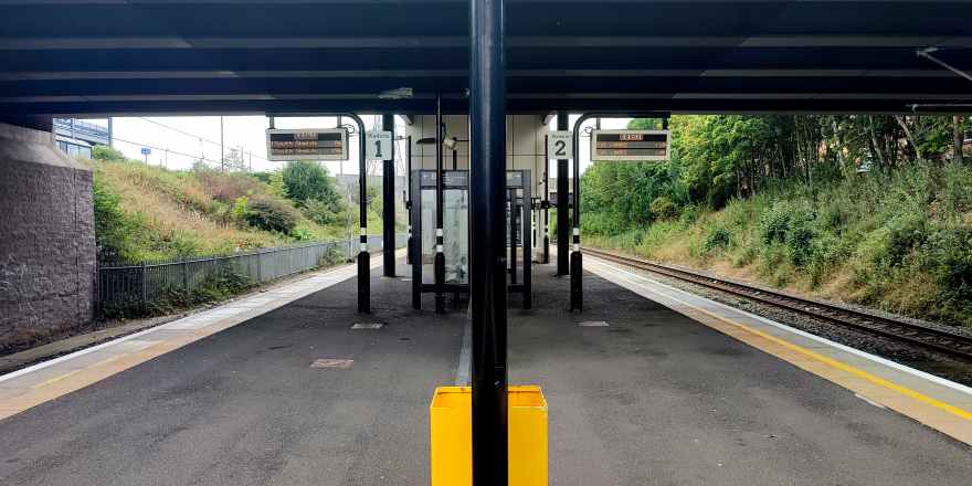
That’s right: you can, if you want, catch a Yellow Line train at Monument, go all the way around the coast, wind up right back where you started, and continue all the way down to South Shields just to rub it in. Put otherwise: there are four platforms and they’re all for the same line.
This is, as far as i know, unique to Newcastle. Bucharest almost gets there, but chickens out just before the line actually crosses over. Sofia nearly pulls it off but, in a shocking display of cowardice, redesignates its Line 4 as “Line 2” halfway through the loop, disqualifying them immediately. The Hague does something even more complicated, but it’s on a tramway and i can’t in good faith count it. And Vancouver used to have the same setup — even using the same colour — but switched to a perhaps more sensible timetabling in 2016 when an extension rendered it unworkable.
So… why? What’s the point? Let’s find out.
As is often the case with urban rail, the constituent parts of the Tyne and Wear Metro were built at different times by different, competing companies, and were only later stitched together into a coherent network.
The first part of the loop to come online was the Newcastle and North Shields Railway, starting in 1839, who ran a service from the centre of town to (where else?) North Shields, later extended a teensy bit further to Tynemouth. The N&NSR’s mighty viaducts still carry our dinky yellow trains over the Ouseburn to this day.
Meanwhile, further north, coal mining in Northumberland was growing rapidly. (This brought great prosperity to the region, which would surely never ever end. Ever. Unless they closed the mines, but come on, why would that ever happen?) The existing main-lines found themselves choked by the influx of traffic, and in 1852, Parliament authorised the incorporation of the newfangled Blyth and Tyne Railway.
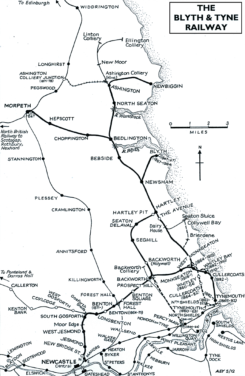
The B&T at first linked Bedlington and Blyth only to the staiths at Percy Main, but by the eighteen-sixties it had added branches to the centre of town — encouraging buildup in Newcastle’s northern suburbs — and to the growing seaside holiday destination of… Tynemouth.
Hm.
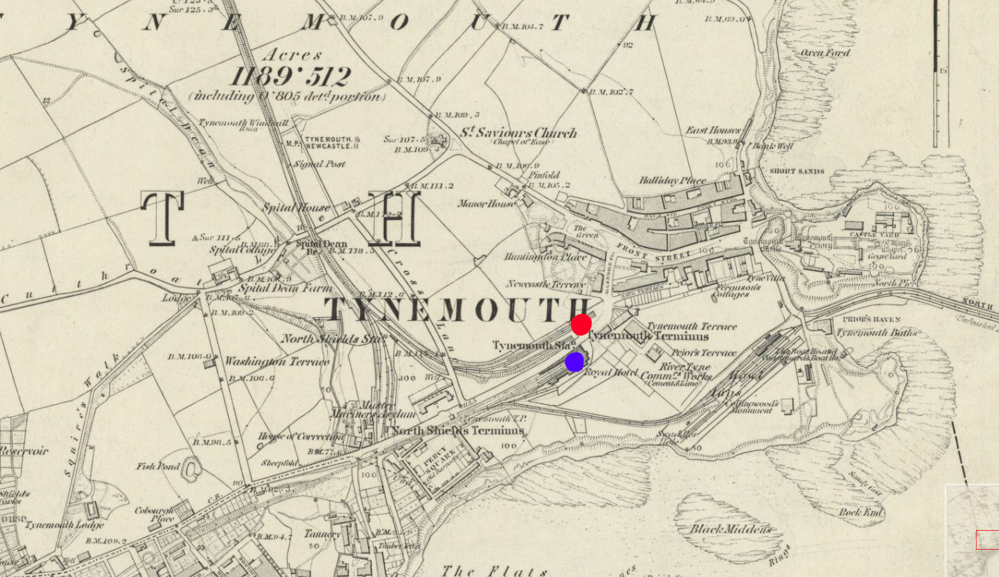
By the early eighteen-eighties, both the B&T and the N&NSR had been absorbed into the North Eastern Railway, which found itself in the awkward position of having two formerly competing stations right next to each other and no way for trains to transfer between the two. So, in 1882, the two competitors’ lines were linked up with a new alignment running closer to the coast, including the opening of a gorgeous palatial through station at Tynemouth, still in use by Metro trains and Sunday markets to this day.
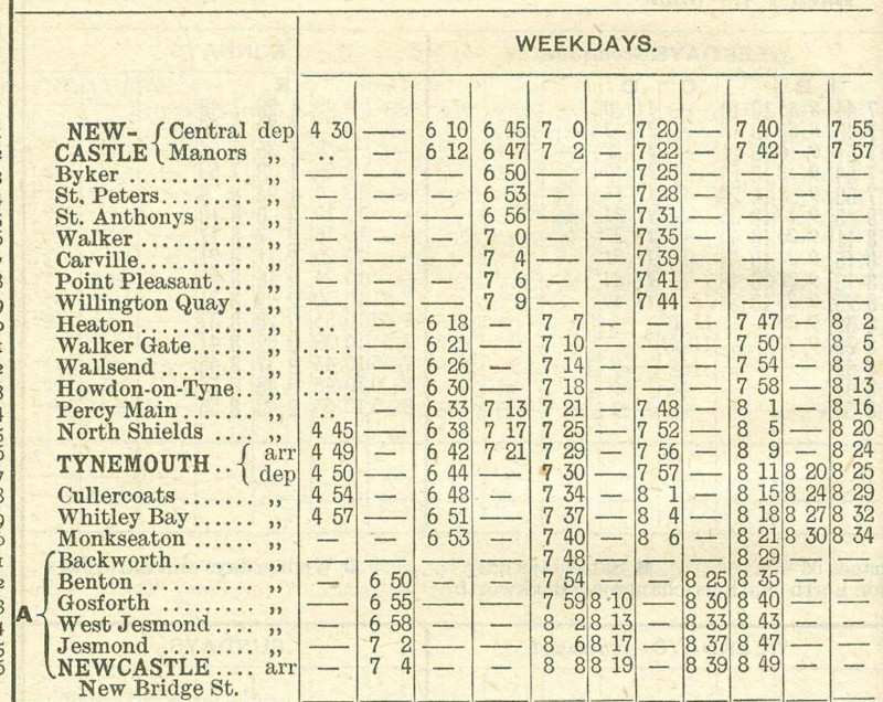
The earliest timetable i could find, from 1902, shows that trains were indeed running in a loop around the coast, from the city centre to Wallsend to Tynemouth and back, just as is possible today.
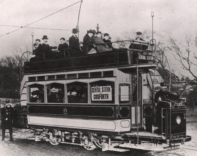
At the dawn of the twentieth century, however, the steam services were threatened by a rising competitor: the tram. No longer did you have to put up with noisy, steam-belching locomotives every day — you could get to exactly where you wanted to go, in style! This, of course, wouldn’t do, and so the NER embarked on a rapid programme of electrification. By 1904, the loop had fully switched over, and the network was rechristened the ✨️ Tyneside Electrics! ✨️
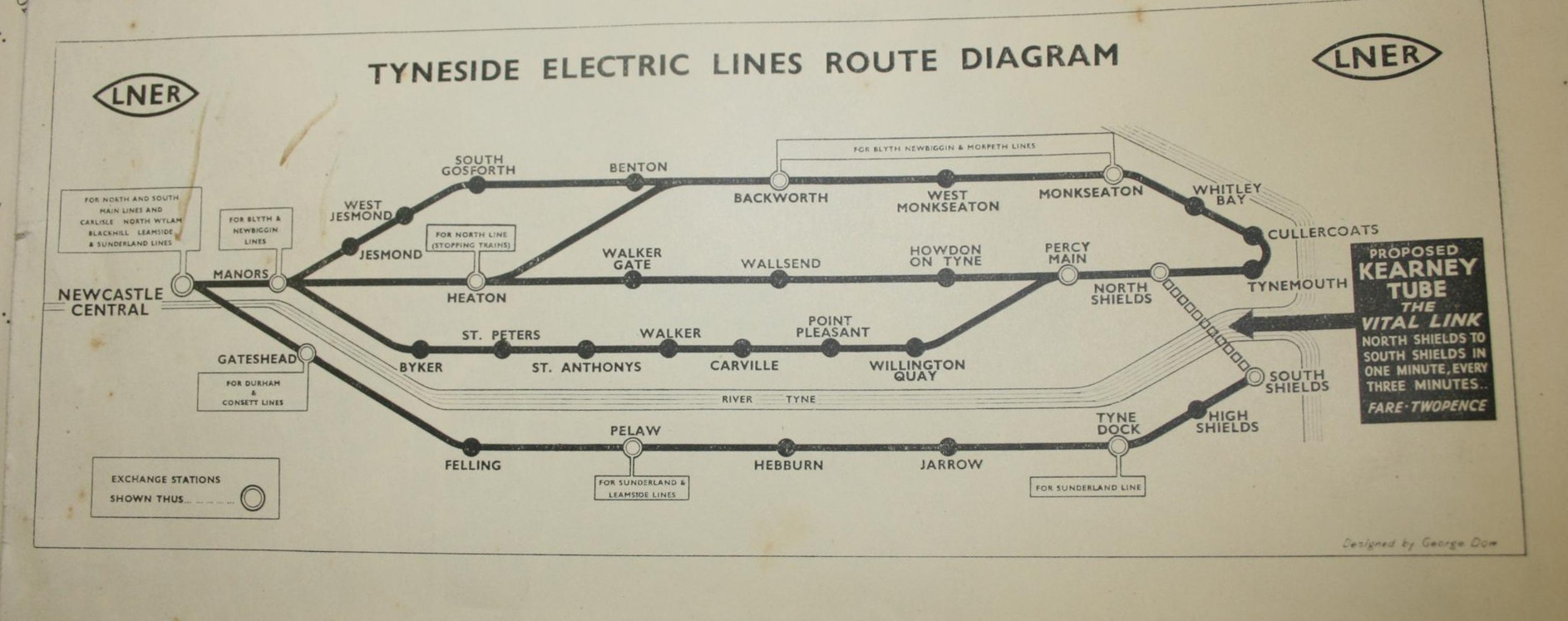
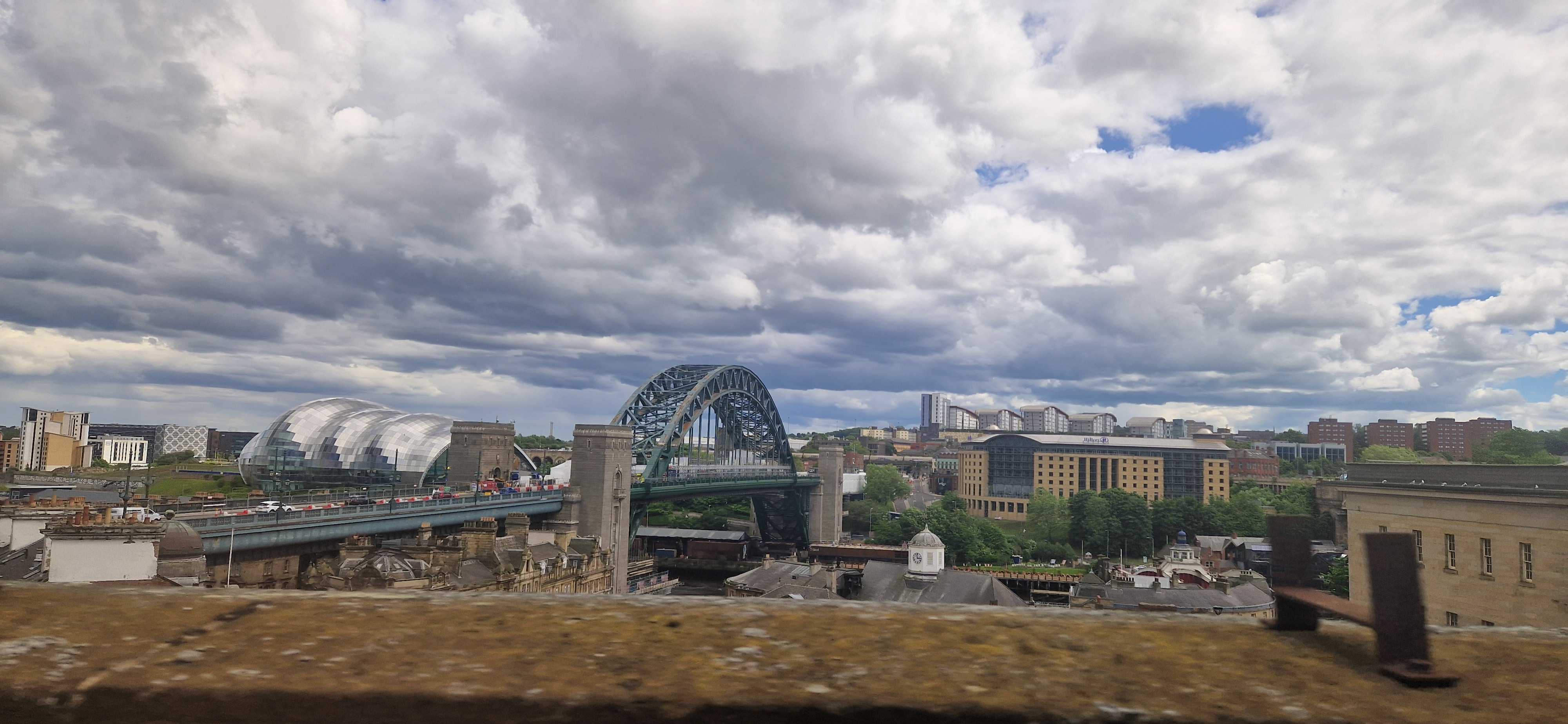
By this point, the network clearly resembled what we have today. Now, it didn’t quite loop over itself like today — everything went through Central Station; no perpendicular Monument tomfoolery here — and there was an extra branch snaking along the riverside which was never refurbished for the Metro era. But other than that, the geometry was pretty well set, and there would be no major service changes until the introduction of — what do you mean, you want to know what the big black arrow’s for?
Whenever i show a diagram of the Metro to my non-Geordie friends, the first response is usually something to the effect of, “Why isn’t there a link between North and South Shields?” It’s a fair question, and the canned answer i usually give is that building one would be a lot of expense for little point, since there’s already a well-trafficked, well-loved ferry service between the two. Little did i know that it could well have been otherwise.
Elfric Wells Chalmers Kearney was an eccentric Australian engineer who spent much of his life trying and failing to convince city governments to adopt his all-new danglebahn, the Kearney High-speed Tube™. Here he is in 1910 with a model he made earlier:
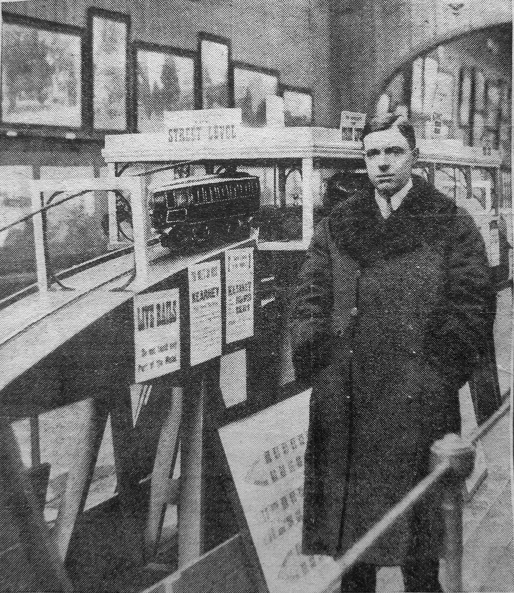
The “Kearney Tube”, as it was known, would be powered by the force of gravity, hurtling down a ⅐ gradient from stations just below the surface like a bizarro funicular before climbing gracefully back up, suspended between a monorail below and a guide rail above, which would (in theory) stabilise the train’s side-to-side motion so as to not induce vomiting in everyone who rode it.
Mr Kearney promoted his invention in cities as distant as Sydney, London, Portsmouth, and (if secondary sources are to be believed) Venice and New York, but it came closest to reality between North and South Shields.
Over sixteen thousand Tynemouthicans signed a petition calling for its construction, and in 1925 the government gave a provisional order approving its construction. Alas, when it came time for a parliamentary committee to give Mr Kearney’s dream the final go-ahead, they were rather more sceptical. He had raised nowhere near enough money to actually build the blasted thing, and the members were quite concerned about the impact it might have on the livelihood of the Tyne’s ferrymen.2
Mr Kearney held a grudge for the rest of his life. He made elaborate, typewritten conspiracy diagrams indicating who was paying off who, and gleefully wrote of the death of his opponents on the committee — or even those who were only tangentially connected:
Under pressure from Lord Ashfield, Henry Ford went back on his undertaking to finance the first Kearney Tube between North and South Shields. Not long afterwards Esdell Ford [sic], Henry Ford’s only son, was taken ill and died.
In 1939,
he gave it one more go, partnering with the LNER — only for the outbreak of the second world
war to put an abrupt halt to any civilian infrastructure plans. He would eventually write
a science-fiction novel titled
Erōne, where his his protagonist’s ideas are proven correct by a utopian society on
Uranus, and if only the good people of Earth would listen!
Mr Kearney died in 1966, never having seen his utopia come to fruition. I was unable to find where or how, or even in which continent he is buried — he split his time between Australia and Britain, and he could plausibly have passed on either side of the equator. Still, i hope he’s up there somewhere, smiling down on all the shweebs, hyperloops, monorails, and other gadgetbahns of today.3
By the nineteen-sixties, the Tyneside Electrics had seen better days. Passenger numbers were falling, the trains of tomorrow were decrepit, and they weren’t even electric — British Rail had deemed it more cost-effective to run slower, dirtier diesel trains. The system had become a kittiwake4 around the North East’s neck. So, in 1971, the local transport executive commissioned a study — and they came back with a plan.
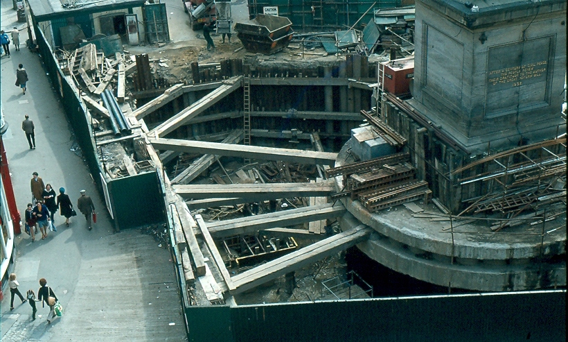
You know how the rest goes. Though the Tyne and Wear Metro would mostly reuse the existing routes mentioned before, they would all be linked up through a newly constructed central core underground — meeting in the middle at Grey’s Monument.
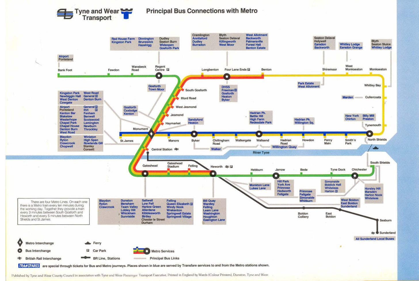
The pretzel shape was completed by proceeding one stop further from Monument to stubby St James’ Park.5 This was just a temporary terminus, of course — the station was built so that, in future, they could easily come back and extend it out to the long-underserved west end of the city. Quoth 1981’s “Tyne and Wear Metro: concept, organization, and operation”:
St James station is at the centre of an area designated for future office development and also serves the football ground; the station has also been designed to allow the system to be extended westwards at some future date.
So, eventually, that happened, right? They turned that little stumpy arm into a full-fledged extension. Right? …Right?
In 1981, environment secretary Michael Heseltine vetoed any further extensions to the Metro system. Since then, the only substantive changes have been in 1991 — inking the airport to the rest of Newcastle — and 2002, when, after twenty years, the Tyne and Wear Metro finally reached Wearside. It is around 2002 that things get a little silly.
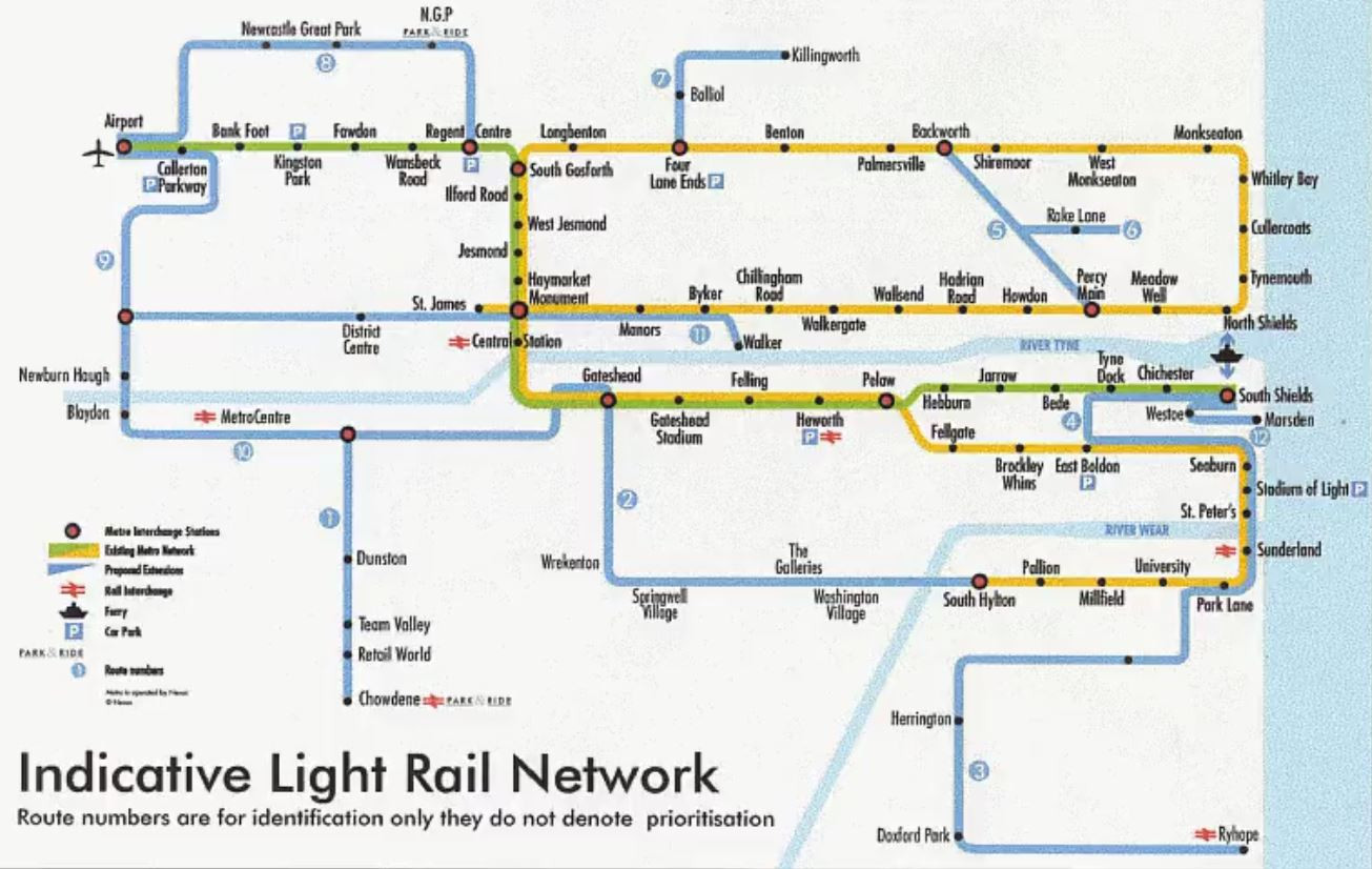
Shortly after service to Sunderland began, Nexus (the local transport operator) announced Project Orpheus, their grandiose plan to build a transport network fit for the twenty-first century. Bus rapid transit for everyone! A cable car in Gateshead! And, yes, the valiant return of trams to Newcastle-upon-Tyne, connecting the west end up with the city centre.
None of this happened. The plans were watered down and watered down until all that was left was the vague idea of refurbishing the Metro and making buses more frequent. The great recession and austerity presumably killed any hope it had left. You still get calls from local councillors to extend the system to their part of the area, but they seem unlikely to amount to much. So is all hope lost?
Well… remember the Blyth and Tyne Railway?
Passenger services along the B&T north of Backworth were given the chop by Dr Beeching in the nineteen-sixties. Combined with the end of coal, this was a one-two punch in the gut for working-class mining towns like Ashington and Blyth, leaving them some of the most impoverished in the country.
Local campaigners have been calling for its reopening since the nineties, initially to little avail barring a token mention in the ill-fated Project Orpheus plan. In 2013, Northumberland County Council started taking the idea seriously. In 2019, the transport secretary gave the thumbs up. In 2021, shovels hit the dirt. And in 2024, for the first time in half a century, trains carried passengers from Ashington to Newcastle.
It may be like pulling teeth, and it may cost more than we might like, but Britain can still build things — and local politicians seem to have noticed! In 2024, work began on the first serious proposal since Orpheus to extend the Metro; this time, to Washington, along the disused Leamside line.
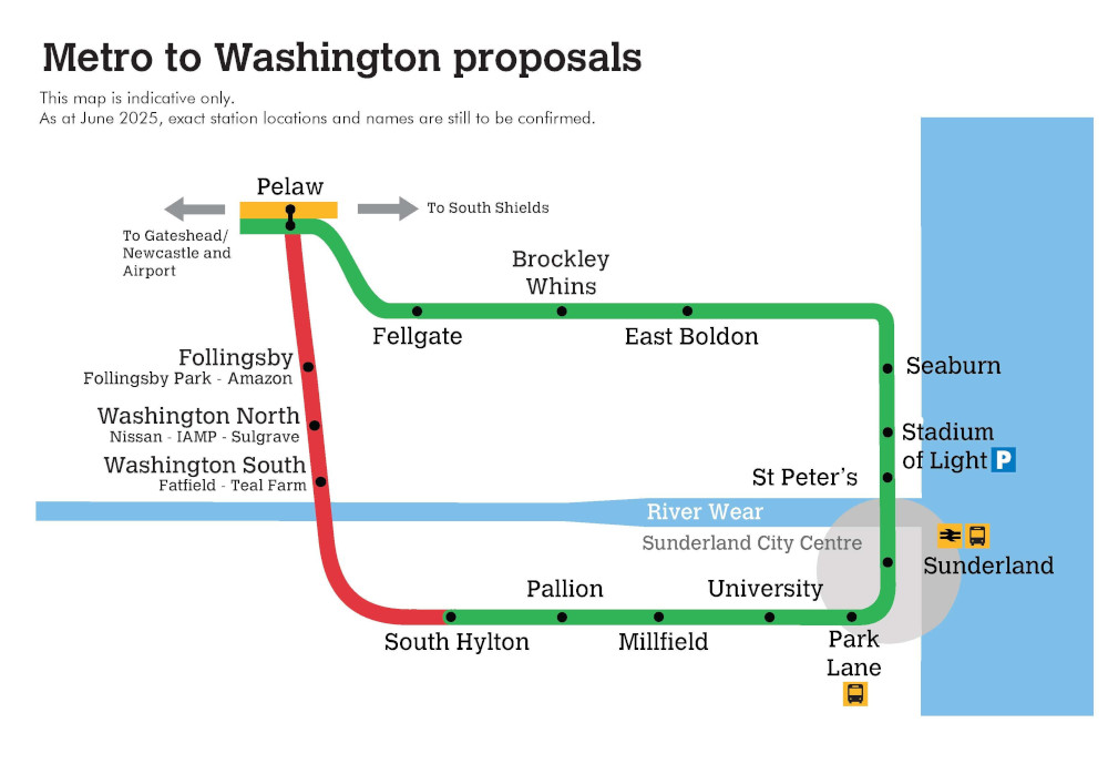
Curiously, the proposed extension goes in yet another loop. It’s hard to imagine this wouldn’t require some rejigging of how the network runs — a third line, perhaps? New platforms at Pelaw? But however they run it, it looks like, if it goes through — and that’s a big if — the Yellow Line may not be alone in its topological weirdness for long.
I’ve done some fairly interesting things this month, and had planned to write posts for each of them — but, for whatever reason, none of them provided that particular spark to me. Maybe they just didn’t seem that interesting to explain to you, the reader, or maybe i didn’t know what to say about them except the obvious.
Nonetheless, it would be a shame for these events to pass into the annals of my journal without telling you about them. So! Here’s a brief summary of my unblogged July thus far.
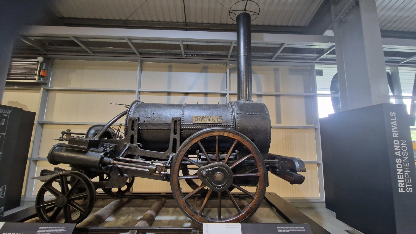
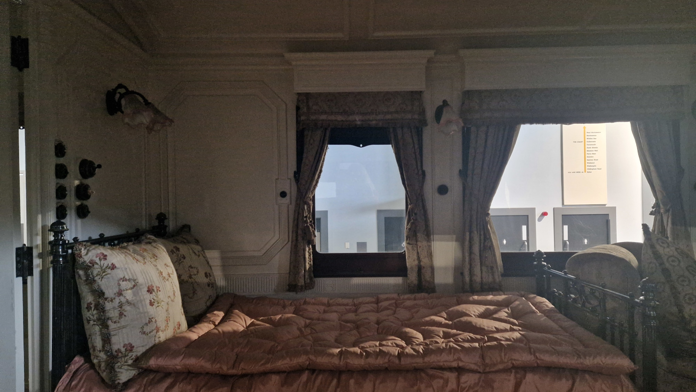
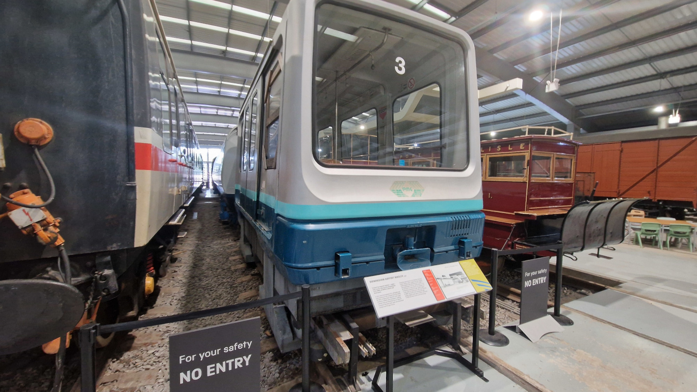
I toddled off to Shildon to visit Locomotion, the local branch of the national railway museum. It’s the birthday of the railways, and thus boasts a disproportionate selection of anorak arcana — alas, you can’t go in the trains, but you get a pretty good look at the inside of Queen Alexandra’s royal train car, the erstwhile Birmingham maglev, and, most proudly, Stephenson’s Rocket.
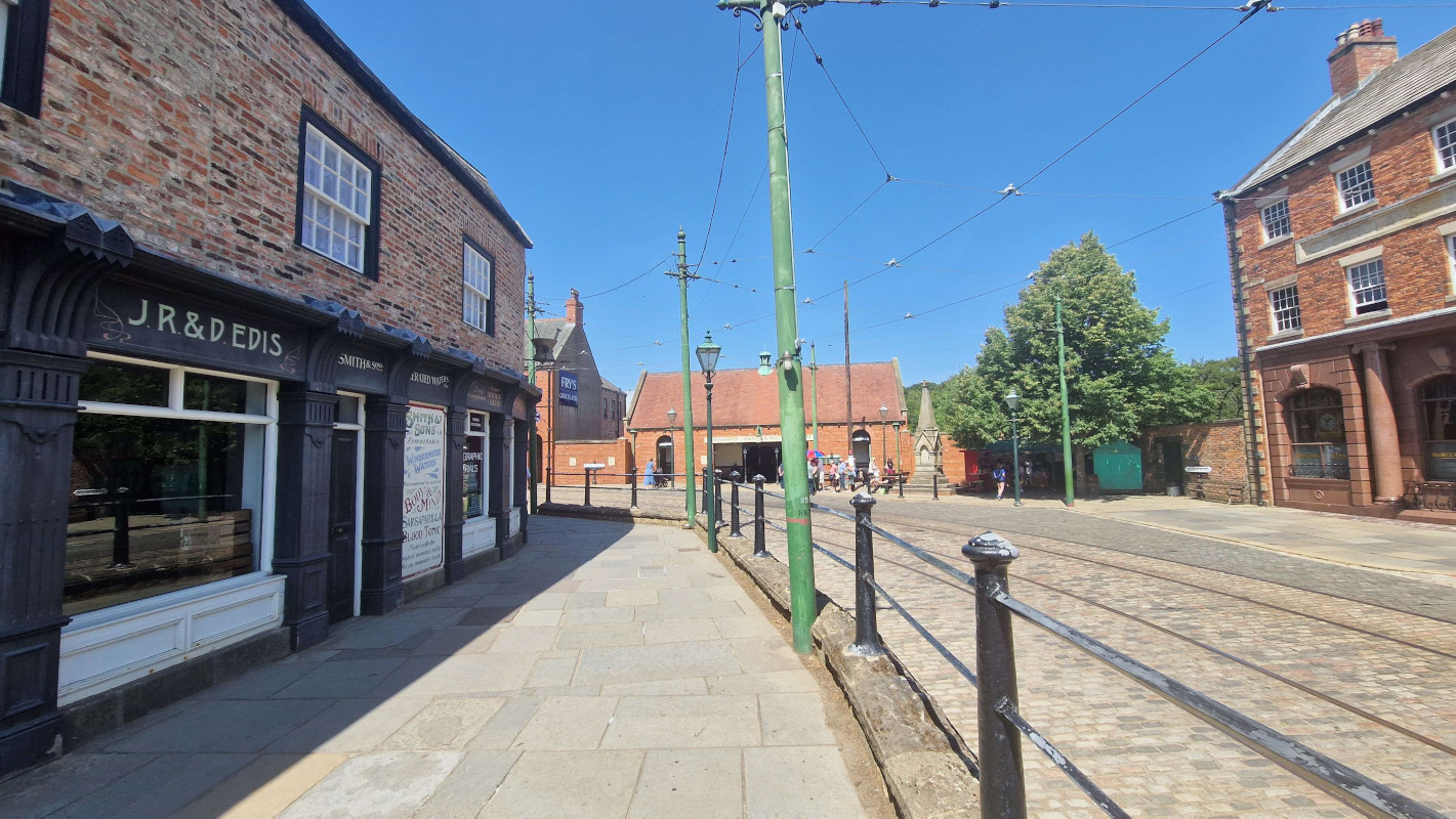
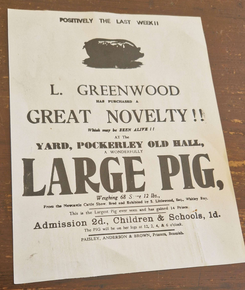
Beamish1 has been newly crowned Museum of the Year, so there was no better time to check it out. I hadn’t properly explored their new fifties town yet — the chippie and the old houses are wonderful, but the record store, crammed up the stairs, across an anachronistically modern mezzanine, and down a grey corridor, leaves much to be desired. Nitpicks about balcony design aside, it’s as great as ever, and, somehow, well worth the £33(!!!!!) asking price.
Finally, just yesterday, i went off to an Elbow concert hosted in a ruined mediæval priory by the sea. Belting out “One Day Like This” in the fading dusk light with five thousand other people standing on the same hallowed ground where monks tried to figure out where baby eels came from is a top-ten human experience.
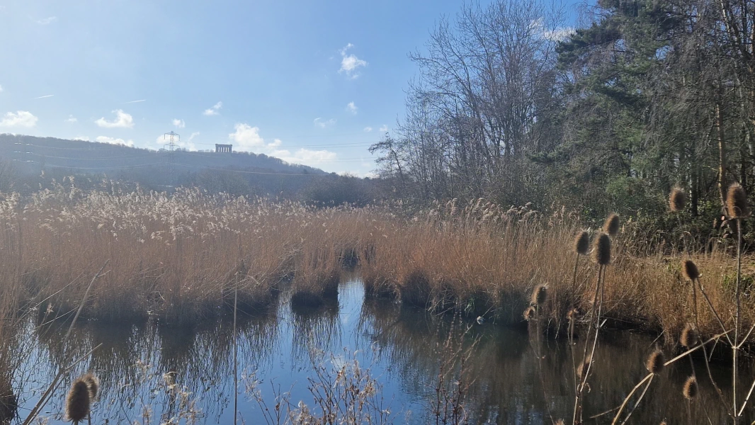
Washington1, a town in urban County Durham long since incorporated into Sunderland, is not a place where one expects much nature. The palatinate’s chirping woods and rolling Pennine moors are not so far away, and the path i took to get to today’s attraction led not through winding country roads but broad, grey industrial arteries, designed to ferry thousands to and from Nissan’s immense factory.
But at the end of the road, down by the river Wear, there lies a wee patch of idyll: the Washington Wetland Centre.
I’d come on a good day for it, clearly, as the first thing i saw coming out of reception was the staff corralling all the ducks together for their annual vaccination, by means of a ramshackle assemblage of mesh fences. (Crowd control for birds!) The littlest one kept trying to escape his jab like an ornithological Bobby Kennedy.
Most fabulous of all creatures of the air on offer are the eiders, the diva-est ducks in the world, emitting a chorus of sassy coos as they revel in their status as undisputed kings of the pond. (You’ll have to take my word for it, as i neglected to take a video, erring towards the side of it being better to live in the moment than through a phone camera. I was yet to realise what good blog-fodder the visit would make.)
On the other side of the preserve a viewing area juts out to overlook the Wear — still salty and tidal this close to the sea — and an artificial saline lagoon, built to provide a home for those creatures who prefer a more brackish milieu. The signs tell me that, rare as they historically have been, more and more European otters have made their home along the wear, and the lucky visitor might hope to see one… if only the centre were open at dawn or at dusk, when they come out.
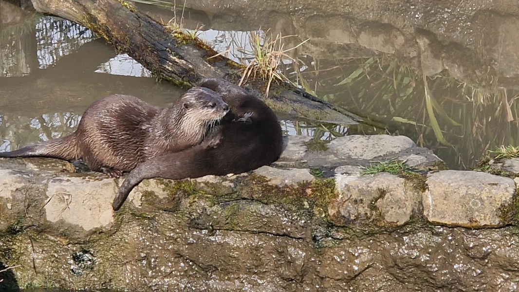
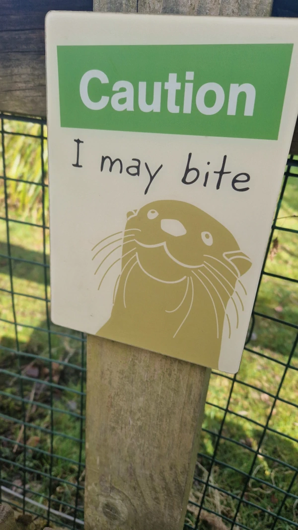
Not to worry, for the centre are also very proud of their main mammal enclosure: a family of utterly2 adorable Asian small-clawed otters. They’re a lot less squeaky than the ones at Northumberland Zoo, and wondering why, two theories popped into my head.
First, that it’s the Northumbrians’ fault. Their northern sibs were greater in number, a family of four to Durham’s two, and they were, by all accounts, masters of putting on a show. They appeared in an orderly fashion when their circadian rhythms told them it was feeding time, pipped and squeaked incessantly at the keeper until they got their fish, performed some cuteness, and then went back inside when their bellies were full. They knew exactly what they were doing, methinks.
Second, that the Washingtonian otters were grieving. I said there were two, the younger Buster and the elder Musa, and you might be hard-pressed to call that a family. But until this month, there were three. Mimi, the clan’s matriarch and a scamp who bonked so much they had to give her a lutrine IUD, passed of old age at fourteen (a good innings by her species’ standards, no doubt). When she went, they had to put her corpse back in the enclosure so the others would understand.
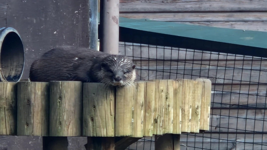
They were still otters. Still playful. But something about them seemed… morose. Maybe, in between the fish and the scampering and the puzzle feeders, they were still thinking about her.
On the way out, i passed a tiny observatory, cleverly named “Cygnus” for the constellation of the swan, used by night for the Sunderland Astronomical Society. I don’t know if it’s of much use this far into the zone of light pollution, but they certainly seem to enjoy it, so perhaps my relatively sky-privileged Northumbrian self shouldn’t play the lecturer. Perhaps that fateful night that Mimi died, a star in the sky began to twinkle a little brighter.
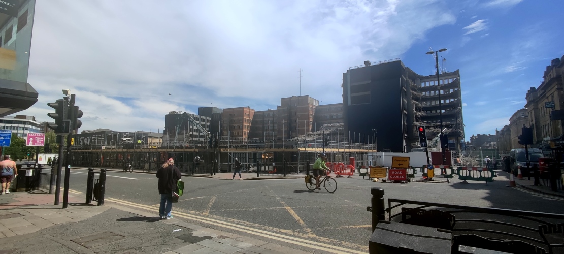
It’s the end of an era in Newcastle, however short it was, as the temporary shipping container food court–cum–public square–cum–shopping centre Stack comes down after three years. The former site of an Odeon cinema was set to be turned into a mixed-use development, but the pandemic caused a change of direction from the developers. The plans have since been slimmed down to just comprise what lockdown proved was truly, 100% necessary:
Offices.
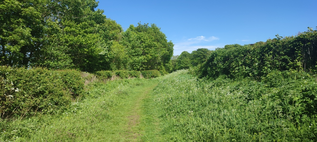
You’d never guess it, but this luscious green path (carefully cropped so that you don’t see the yawning gravel service road behind the camera) is on the former site of a colliery in Bedlington. There’s not much left to see — the neighbouring pit town was bulldozed in the ’70s, and the farmers have done a bang-up job of hiding any traces of the mines that lie underneath.
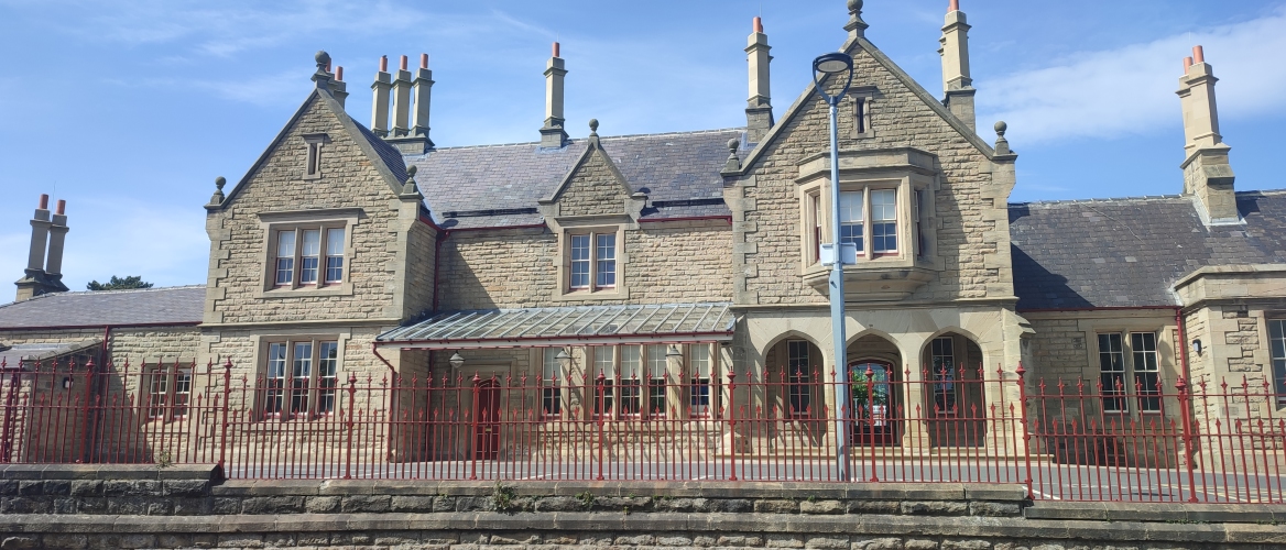
After 2.3 million pounds and a skyscraper’s worth of scaffolding, Morpeth’s central station has finally been restored to its former Georgian glory, red fences and all. The locals will be pleased to know that Lumo, a sparkly new Ryanair-ified third-class train service from Edinburgh to London, have no choice but to stop here thanks to a sharp bend in the track.
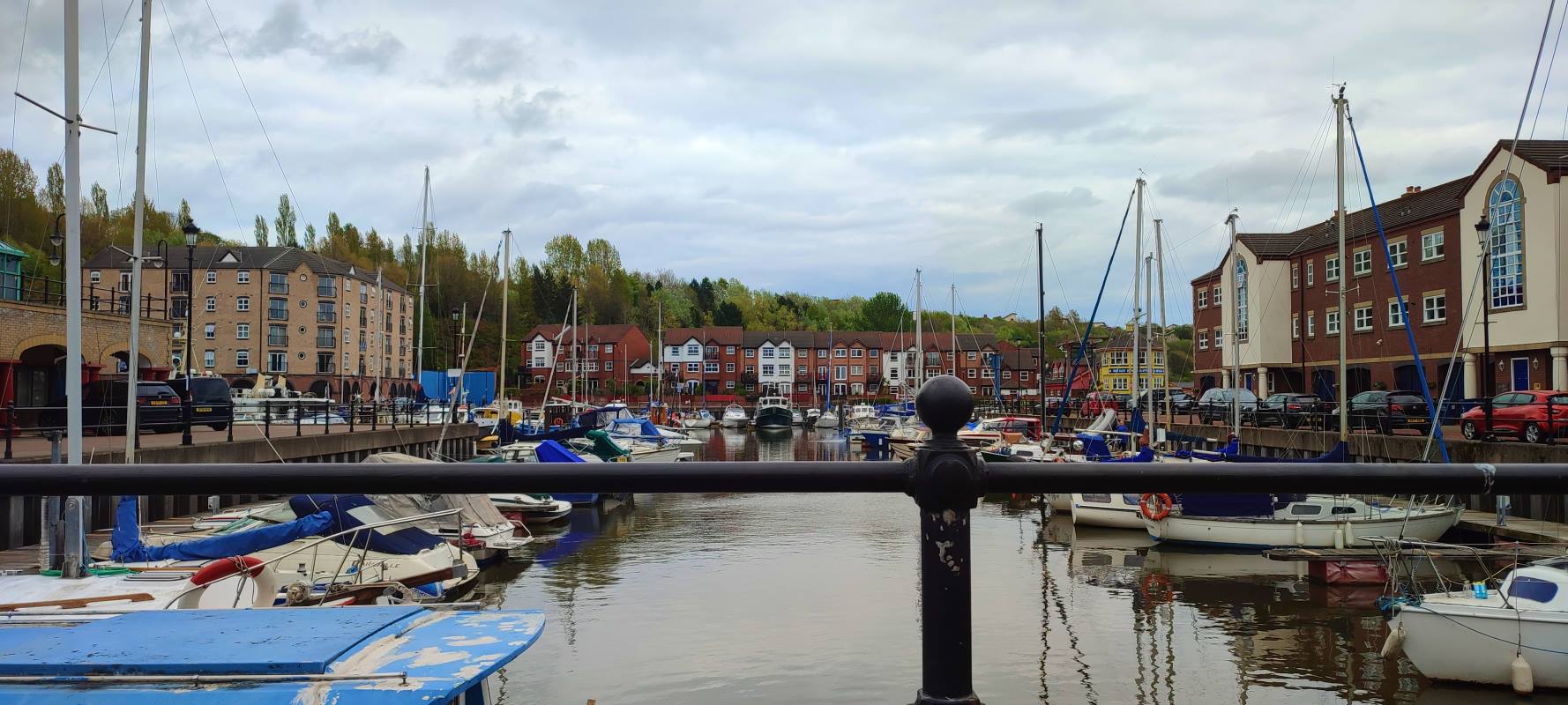
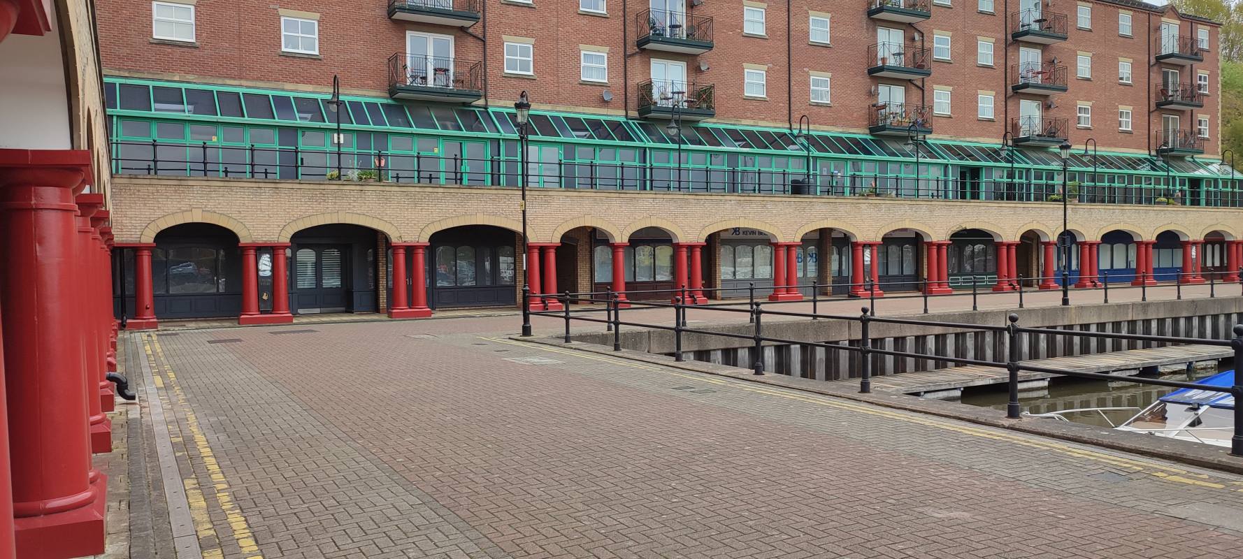
St Peter’s Marina confuses me. It’s like someone dropped a quaint postwar Dutch town centre in the middle of a grimy industrial waste, The river still stinks, and the architecture is — generally — an unconvincing pastiche. Just who is living here?

I was on my usual city constitutional the other week when i noticed that my favourite bubble tea place1 had shuttered. Hm, that’s odd, i thought. Last time that happened was lockdown. Don’t know why they’d do it again. I assumed they’d be back again swiftly, and went on with my day.
Then the week after i noticed that the entrance to the über-hip shipping-container food court of which it was a part was blocked off. Hm, that’s odd, i thought. Ah, well. It’s probably just construction. These things happen all the time.
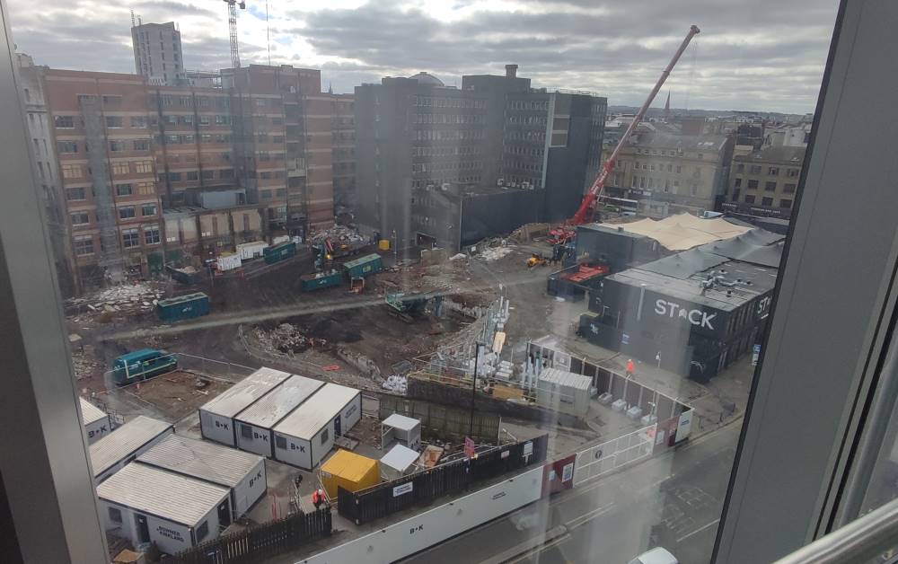
It was only yesterday that i saw the crane lifting one of the shipping containers away and realised something (other than the container) was up. Sure enough, one quick google reveals the flashy new development that’ll be taking its place — originally it was going to be mixed-use, but covid crunch caused them to scale back to the thing that covid really, conclusively proved was absolutely 100% necessary and in demand, definitely: offices.
“Pilgrim’s Quarter” is part of a broader redevelopment of the neglected Pilgrim Street, which may or may not include a pedestrianisation — i don’t know; it’s all in jargonese and i can’t make heads or tails of what Enhancing The Public Realm is meant to mean. (Or, for that matter, why they’ve misspelt it as “Pilgrim’s Quater” on the official brochure.)
The permission slips are all in place — so here’s to you, Stack. You might have had some exorbitant prices (sorry, Korean place, but i’m not paying £12 for a few chicken wings and fries), but otherwyze you were a shining beacon of small businesses in the city centre — you were too good for this world. *Pops open a bottle of champagne*
Down a narrow alleyway to the back end of St Nicholas’ Cathedral, in Newcastle, one can find a rather curious decoration garnishing a door on the opposing façade. The “vampire rabbit” has stood watch over the cathedral for at least half a century; while records are scarce (a quick search of Google Books doesn’t bring up anything until the twenty-first century), it could well date back to the building’s construction in 1901.
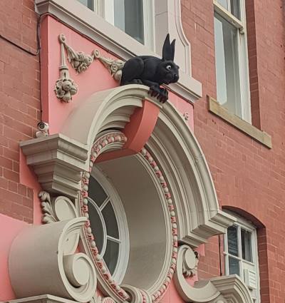
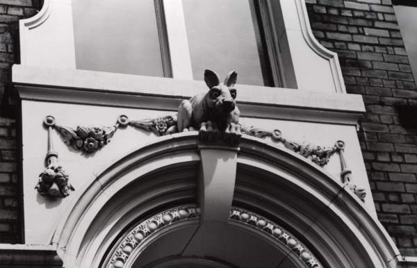
Here’s the thing, though. Nobody knows how it got there. Indeed, even the name “vampire rabbit” is a misnomer; its jet-black fur and red claws were added on some time in the 1990s,i as were its distinctly batty ears. Some say it was put there to scare away wannabe graverobbers, but i have my doubts that twentieth-century crooks would be so dumb.
Yet others posit that it represents a mad March hare, arising at the time of Easter, or that it refers to Thomas Bewick, a nearby engraver who had a fondness of all things lagomorphic. Most fascinatingly, a theory advanced by one Mr Adam Curtis suggests a Masonic pun in reference to one George Hare Phillipson, a local doctor (hence vampires) and active Freemason, as was the lead architect, one William H. Wood. It being a secret society in-joke would also explain why it’s located around the back, rather than the front, which faces onto one of the busiest streets in town.
Perhaps we might never know for sure. In any case, it’s a fascinating little secret — what do you think is most likely?
Last time on The Garden: the axe falls on the Blyth and Tyne line, and i foolhardily decide to walk its length…
Our journey begins at Northumberland Park, in North Tyneside. Though it’s the first station we’ll be visiting, it was the last to be constructed, having only opened in 2005 — and it’s quite easy to tell, even after sixteen years of wear and tear; the place is outfitted with modern amenities, lifts, ticket machines flush with the wall, and, more lately, pandemic-themed graffiti opposite the platform. This unassuming metro station will, according to the county council’s plans, serve as the interchange between the old and new lines, heavy rail and metro meeting one last time before splitting apart and going their separate ways.

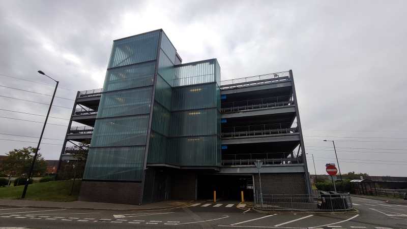
Setting off from there, the first thing that caught my eye were twin giants: a frosted glass-covered car park and a red-brick Sainsbury’s, unexpected icons of the modern British condition. It didn’t get much better from there; down the road lies an American-style strip mall lined with bookmakers trying to get people to piss away all their money.
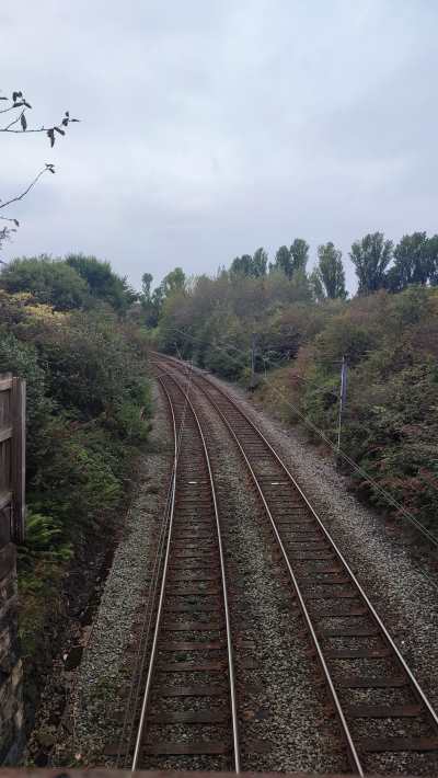
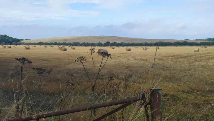
This southernmost tip of Northumberland is criss-crossed by innumerable public footpaths, cycle paths, bridleways, and other routes for non-metal-box-related transport; ducking onto one of the reclaimed “waggonways” once used to transport coal, i found myself on the site of the second station on the list.
The leafy suburb of Backworth has a habit of burying its history. A hoard of offerings from Roman times was found underground in the 1810s, the last vestiges of the colliery that once was are long gone, and the tale of this sorry ex-station is rather similar. Opened in 1864 to replace a nearby station closing the same day, Backworth station served its community for over 100 years, surviving the Beeching cuts. But when the Tyne and Wear Metro was announced to come to town, the old station finally closed… for good. It wasn’t until the opening of Northumberland Park that there would be a replacement.
As i wandered through the village's verdant streets, i couldn’t help but think of its resemblance to the straight, cycle-friendly streets of my old hometown. A little greenery can go a long way.
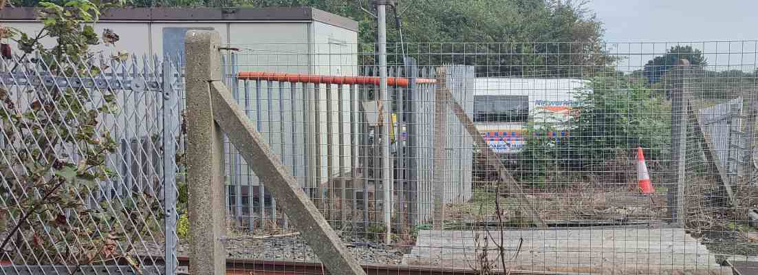
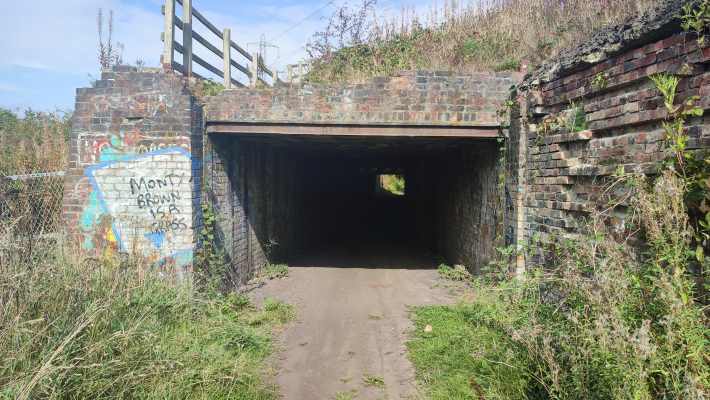
Network Rail were hard at work at the site of the aforementioned original Backworth station, whose plot of land now sits vacant, marking the city’s last hurrah; the further i walked along the dirt back roads, the further the sounds of bustling cars receded, until, ducking under a shady underpass, i found myself utterly alone amongst pastoral fields (and the overwhelming scent of manure).
That peace and quiet was swiftly interrupted by a troupe of boy racers on motorcycles and quad-bikes, but you can’t win them all, you know?
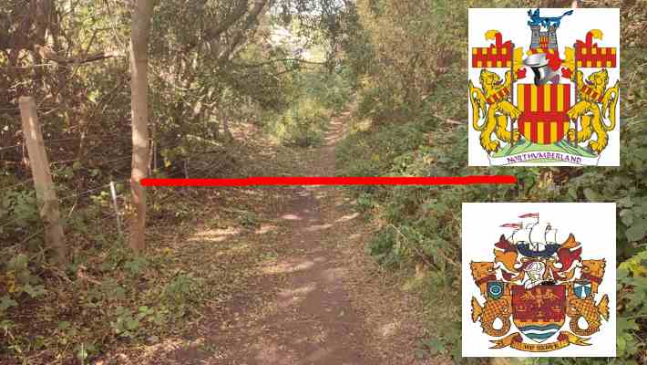
The (post-1974) border town of Seghill occupies only the tiniest fragment of the collective English consciousness, popping up briefly in an anti-scab miners’ folk song called “Blackleg Miner”:
It’s in the evening after dark,
when the blackleg miner creeps to work
With his moleskin pants and dirty shirt
there gans the blackleg miner![...]
So, divvint gan near the Seghill mine
Across the way they stretch a line,
to catch the throat and break the spine
of the dirty blackleg miner[...]
So join the union while you may
Divvint wait till your dying day,
for that may not be far away,
you dirty blackleg miner!
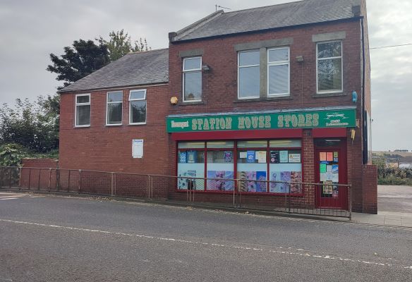
For our purposes, it’s chiefly notable for the fact that it’s the first disused station on the list whose buildings are still intact and in use, this time as a corner shop, from which i of course bought a copy of the local rag — prominently including a Q&A about the restoration of service on the line, which i thought a fitting reminder of why i set out on this silly old journey in the first place.
After getting some well deserved rest, i headed on off towards the next town over, awaiting what fresh stories i would find...
Next time on “Walking the Blyth and Tyne”: your author is reminded of her own mortality, finds himself in the company of a noble family, and shudders at the thought of having to go to Blyth, of all places on Gods’ green Earth
The Victoria Tunnel runs beneath the streets of Newcastle, from the Tyne up to the Town Moor. It traverses not only space, but time, through nearly every corner of England’s history: built to transport coal in the Industrial Revolution, on the site of an old Roman spring, it was used during the second world war to house those fleeing German bombs. It was even considered for use in the cold war, before the government realised that some musty old coal tunnels would probably not provide the greatest protection against a nuclear blast.
And now you can go down it. In 2007, Newcastle City Council decided to refurbish the tunnel and open a small stretch of it — the rest is either unsafe for sending humans down or currently in use as a sewer — up for public tours. Entry is via a side street along the Ouseburn, where the guides will cheerfully show you a map and some old photographs of the entrance. Once you get inside the tunnel itself, hard hats and torches are compulsory, and covid restrictions are still in full force. This was both a benefit and a malefit: yes, the tour was shorter than it would otherwise be, and masks get quite uncomfortable when you’re wearing them for an hour in a dank, dark tunnel, but on the other hand, our small group of family and friends got the place practically all to ourselves, without having to be shepherded alongside other members of the public.
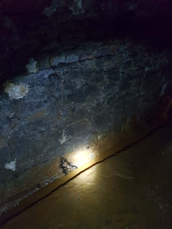
The tunnel is just barely wide enough to fit three people side-by-side, and if, like me, you’re of a certain height, bumping your head on the roof is practically guaranteed. By every blast door, there’s a plaque about what’s above you, and how it factors into the tunnel and the city’s history, stories with which the guides will gladly regale visitors (including some rather grim tragedies).
Coming back out the entrance, i felt more informed about this wonderful county’s industrial history — just in time to pop over to a gentrified vegan “superfood pub”. The wonders of modern life.
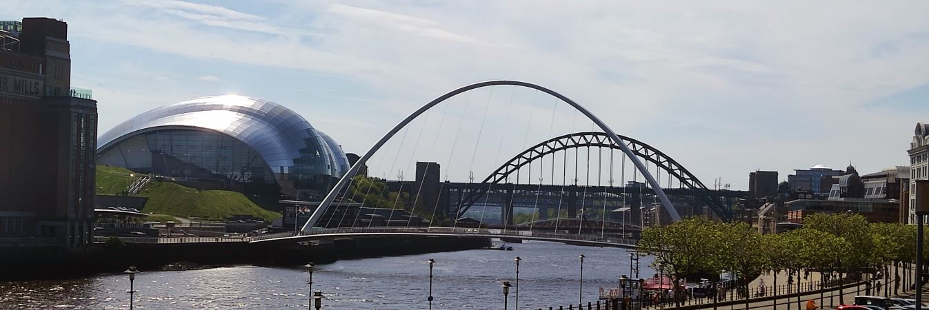
The gorgeous gorge that is the Tyne valley has no shortage of winsome views, but the most beautiful, in my opinion, is that which appears to one who goes down the Side.α In the Monument’s shadow, after passing the classical columns of the Theatre Royal and descending Grey Street as it becomes Dean Street, finally taking a turn onto the Side at the bottom, the lucky traveller will find themself towered over by the behemoth that is the Tyne Bridge:


I’m not sure any photograph can ever match what it’s like to be there under that bridge. One of the most remarkable things about this view, though, has nothing to do with the view itself, but rather what happens if one walks down the Quayside for a little while, reaches an empty brownfield plot, and clambers up a set of rotting wooden stairs to its right. Because, inexplicably, just a few metres from the most beautiful view in town, one can find the second most beautiful view in town, a glorious lookout on every bridge linking the two banks of the river.
We don’t deserve this city.
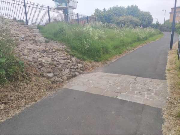
I had initially neglected to bring a water bottle along with me; i had only intended a quick jaunt to the centre of town and back, and the foolhardy idea of walking all the way to Wallsend came to me spontaneously. This quickly proved a bad idea, and so i made a trek up to the corner shop, who thankfully had all the bottled water anyone could ever want or need.
After leaving fully rehydrated and ready to walk back, i noticed the most wonderful little thing. A parklet, this small opening of green space with some benches and inscriptions, tucked between a housing area and a construction site. I took some pictures — i would have loved to show them to you, but alas, my phone got stolen in the intervening time between this trip and me writing this post, taking the photographs with it.
Nevertheless, if you’d like to visit (or live vicariously through Google street view), it’s that little park adjacent to 5 Belmont Street. (Google stubbornly refuses to give a proper address, but you can’t miss it!)
An account of my thought process upon seeing the above building complex:
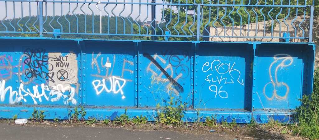
Just a few yards ahead, crossing a foot-and-cycle bridge, i happened upon some strikingly relevant
graffiti, alongside some other pieces which really sum up the modern English psyche: an Extinction
Rebellion poster, a crossed out “EDL”,β and a cock and
bollocks.
I carried a record from HMV (the Killers’ Hot Fuss, if you must know) the whole way, and let me tell you, my arms were positively aching by the end of it! At least i had a bag…γ
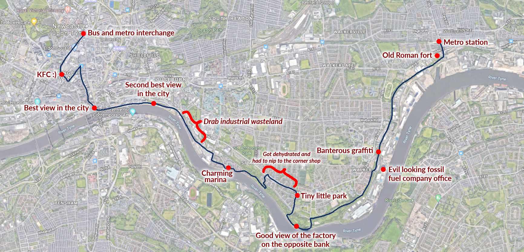
To sign off, here are some photos whose stories weren’t interesting enough to make the cut, as well as a map of the journey. Thank you for reading this disjoint mess.